| |
| |
Venta de Chaleco - Turon
s(u)
It is often the case in landscapes
like this, that the really interesting points -
and there are some really interesting and scenic
points - are somewhere along the route, and
not at the summit. That makes organizing a summit
list sometimes a little cumbersome. So this is the landscape context for
this summit point: The Sierra Contraviesa occupies
the scenically strategic position between the
Mediterranean Sea and the Sierra Nevada. Close to
its ridgeline runs a road, and this is one of at
least four paved summit points on it. Along the
way the road runs through several so called "low
Alpujarra" villages. They are close to the
ridgeline with great views, but the name "high
Alpujarras" is reserved for the Sierra Nevada
villages, even if many (if not most) high
Allpujarra villages are actually lower.
The scene along AI6300, above the river Adra
river is a curiously fascinating mix of ruins,
houses that were destroyed from a flood caused by
a dam break in the 60s, and the villas that were
high enough to survive. In the rebuilding phase a
commnity of european expatriots, with a new found
freedom to live where ever they want to, has moved
into parts of this area. This is my actual
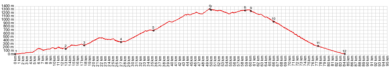
starting location for this ride. This ride stays in the valley. You catch a glimpse of the Mediterranean behind the white cubistic sprawl of Adra. The surroundings are stark dessert valleys. But the road still manages to have more turns than a mountain pass, and follow every detail of the dessertscape. It turns perpendicular to the right. apparently to pass between two groups of houses, back 90 degrees to the left to cross an old stone bridges. More roadside interactions follow. The first goal, that is a real landmark, is a tree on top of a hill. Here the viewshed changes. On the other side lies the Embalse (reservoir) de Beninar . This is the junction with the route to the summit point A347 Alcolea(sh). The route described here turns left across the dam.
The switchbacks above the reservoir open the
first far views, and I have them to myself - no
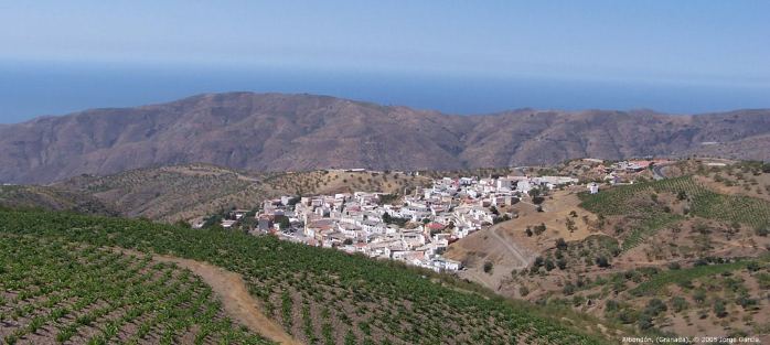
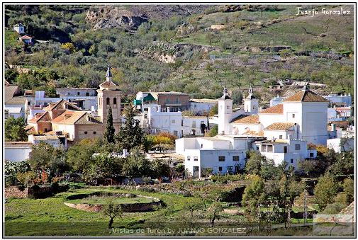
cars to speak of. The next village, Turon, is the
highlight of this ride for me. I take pictures
very similar to the ones that some nice flickr
users let me use for this page, but then also many
other pictures from wandering around the stark and
lonely streets of this old village. The small
group of houses is organized around two old
churches and their balconies. An old man strikes
up a conversation with me and esquires about my
origins. Leaving Turon and climbing the road above it in
switchbacks, I wonder if clouds are obscuring the
Sierra Nevada in the background, or if this
village is sheltering in a depression from the
wind. After this the road stays mainly south of
the gentle, saddle shaped ridge, so that views of
the Sierra are rare. What seems like gentle
rolling hills allow fast progress along the
ridgeline The next intersection is signed "Venta de
Chaleco". The highest point along the route is
actually a short distance before reaching it.
From West. (described
downwards). The profile turns left here and stays
on the south side of the ridge top. The now even
faster road crosses another signed Venta, which
seems to be mostly a restaurant of some sort, and
dips about a 100m before climbing the same amount
again. Given enough energy one can keep going along the
ridge to a point slightly higher than this one: Haza del Lino
- Albondon s(u). But this profile (as well
as my ride) descends back down to the
Mediterranean Sea at the first chance, A345 to
Albondon. Looking back from this part of the road,
there are again a few amazing vistas of the Sierra
Nevada. Albondon has the white cubistic Alpujarra look
from a distance. But as I roll through it, I
notice that this is a completely different animal
than Turon. At the center stands some multi star
spa fitness hotel, and people in stretch pants
radiate out from it. The closeness to the coast
seems to provide more opportunity to harness
tourist spending. Below the town public balconies
along walks paved with flagstones, show off more
vistas. The roll down continues. Finally I reach the
first viewpoint above Albunol, surrounded by more
refuse and garbage than I have seen even on the
coast below. This is a completely different town
again, larger with a more industrial high rise
agricultural base, but still all in white. The road follows one of the largest dry, flood mitigation stream channels that I have ever seen. If I have seen a larger one, it is in one of the adjoining villages right here on the coast. Part of this road parallel to the flood contruol channel is somewhat narrow, and actually has traffic - even quite a bit at times. But it doesn't last long. Climbing up this road in the morning one often has a tremendous head wind, that can force you to modify your goals for the day, at least during certain weather conditions.
Dayride with this point as highest summit: COMPLETELY PAVED: ( < A345
Alcolea(sh) | Puerto de Haza
del Lino(sh) > ) |
|
|
advertisement |
|
|
advertisement |