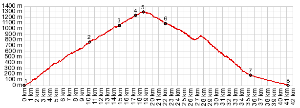
The Sierra Contraviesa is in a scenically blessed location. For roughly 30km it separates the Mediterranean Sea and the Sierra Nevada. A road runs near the top of this rounded range and the Haza del Lino is one of its most popular road cycling goals. The Haza del Lino is close to the highest point of the road. But actually it is nothing more than an intersection with a restaurant a few other interesting buildings (more below). Sevaral summit points are nearby. The approaches described on this page, are the ones closest to the "Haza del Lino intersection". This is also the most westerly summit on the ridge road and it has the most spectacular views of the Sierra Nevada.
To me it is a strange looking scenery, that I
have to get used to, but in retrospect I became
very attached to it. On the countless curves of
the lower approach I see just one car. A woman
gets out and takes pictures. As the views get ever better and cover more blue,
and more shades of blue, the geometric patterns
change. Now the square grid pattern of almond and
other cultivations dot the landscape like the
pattern on a screened image. The road passes by
Popolos. I seem to remember a very narrow stretch
on this next serving of spaghetti salad turns.
Then the road meets up with another approach
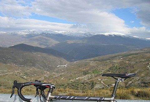
coming up through Sorvilan. Here the profile turns
straight east. This is the best vantage point on
the Sierra Gador and the clouds mystifying its
summit, that I have seen on this trip.
Unfortunately the pictures are on a computer that
was stolen. Running close to the rounded ridge, the road is
now further away from open views of the
Mediterranean, and still not on the ridgeline
itself. Here the scenery is dominated by grid
pattern fields and the forest that was allowed to
remain around it.
Approaching the Haza del Lino, it turns out to be
just a restaurant at a signed intersection, with a
few additional houses and a handful of parked
cars. Turning left or right here leads as close
along the top of the ridge of the Sierra
Contraviesa as you can get on pavement. This
option turns left. Immediately after the turn, a pruned old tree is
the most photographed subjects along the route.
The many photos on flickr, google earth and other
photo web sites are evidence. I too photograph
this tree in about a dozen variations, with my
bicycle as fore- middle- and every other
imaginable- ground. But since these photos are no
longer with me, I am going to try to use some from
the web to show off this great spot. A nearby ruin
complements the tree perfectly. The true summit is a short distance further up
the road - a very inconspicuous point in the
forest, very difficult to determine the exact
highest point. There is actually another Haza del
Lino sign up here. But, according to the gps, It
too seems to miss the highest point by a short
distance.
This is not the only way down, but the logical
way down for a dayloop. Alternatively, staying
right at the next intersection goes to the Puerto
Camacho (1125m) and descends in direction of the
high Alpujarra villages. Dayride with this point as highest summit: ( < Venta del
Chaleco s(u) | Haza del Lino
- Albondon s(u) >)
|
| |
| |