| |
| |
Col de la Cayolle
Some types of rides
are especially tempting. One such type is a loop
ride, that cannot be made any shorter, yet at the
same time it's just "short" enough, so that - with
good effort - it can be completed in a day. And
that doesn't even mention the scenery, which helps
to make this an extremely popular cycling
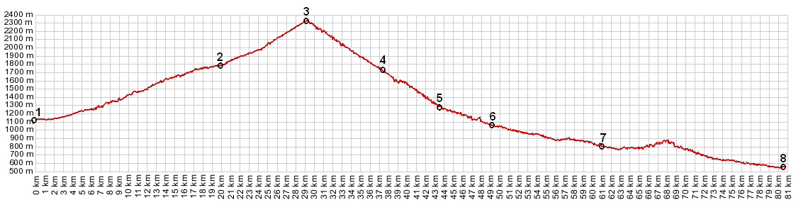
destination.This is the highest point on such a
ride. My extremely small, informal personal poll
also had the result, that this is the favorite
pass on this loop. For the most part the route is
located inside the Mercantour National park, and
as you might suspect, natural beauty is the main
attraction here.
During my traverse of this route during a week day in early June, I saw more bicycles than cars on the approaches to this pass. As far as the entire Cayolle - Champs - Allos loop is concerned, the riders mainly concerned with scenic beauty seem to prefer the clockwise direction (Cayolle first). The exception seems to be the contingent that is worried about road conditions. They prefer to go up the rough western side of Col des Champs, and descend on the wider good road. I saw roughly the same number of cyclists in both directions during my ride. The pass marks the border between the Maritime Alps and the Haute Provence Alps. It generally opens sometime in May. picture page
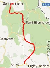
From North. When leaving
Barcelonnette heading north, and you haven't made
up your mind yet, what pass road to attack first,
you don't have much time to decide. Either it's Col de Allos or
Col de la Cayolle. Col de la Cayolle has a longer,
more gradual approach from this side than the
other option. A narrow bumpy paved road follows a
narrow gorge, carved by the river Bachelard. In
the early morning deep shadows keep the bottom of
the gorge and the road cold. There are many narrow
one-way sections and a few interesting small
bridges. The road gradually climbs to half height
of the canyon. By the time the road has reached
Bayasse, you are in a high valley surrounded by
peaks. The road crosses the Bachelard, and now now
climbs out of the valley between meadows and open
forest to the pass, crossing two picturesque stone
bridges along the way. The approach and of course
the pass are inside the Mercantour National Park.
The summit is not commercially overdeveloped, as
it might be ouside of a National Park. In fact
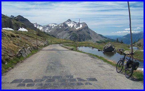
it's not commercially developed at all. The high
alpine meadow at the summit seems to be a very
popular hangout spot for cyclists.
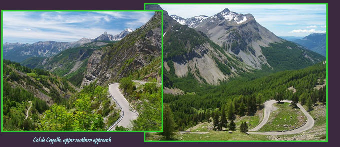
From South. (described
downwards) All of the upper section down to
Entraunes has a rough, bumpy road surface. And
still - I was the only one with a mountain bike on
the entire loop that day, and there must have been
hundreds of road bikes. The road descends into the
upper valley of the river Var. This river gets to
sealevel in record time, so to speak, so you might
expect a strong vertically falling landscape. And
you would not be disappointed. The fast descend is
slowed only by the waves of asphalt, the many
serpentines, and two reasonably dark, but short
tunnels. Another thing that slowed me down was
stopping for the incredible far views of the
peaks, and some amazing water falls on the lower
section. After passing through the small stopover
point of Estenc and then the slightly larger
village of Entraunes, the road "normalizes". It
takes on regular width, smooth surface, and a
correspondingly larger amount of automobile
traffic. The turnoff to Col de Champs is a
hard right, but it is well signed. The profile
follows the valley lower to its junction with the
river La Galarge and N202, between Annot and
Puget-Theniers. History Like many of the passes close to the border area of Italy and France, the origin of the road is military reasons. What was a mule trail in the early 1900s was built into a road between 1907 and 1914, prior to WW1. This completed a road between Nice and the Ubaye Valley to the north. Cycling-Tour de France:
This pass was three times on the Tour de France
route, during times when rougher roads were more
common. These are the rider who were in the lead
at the top of the pass: 1950: Jean Robic (France),
1955: Charly Gaul (Luxembourg), 1973: Vicente
Lopez Carril (Spain). Dayride with this point as highest summit: Col
de la Cayolle , Col
d'Allos , Col
des Champs : St Anne la Conamine
> Jausiers > Barcelonnette > Col de la
Cayolle > St Martin d'Entraunes > Col des
Champs > Colmars > Allos > Col d'Allos
> Barcelonnette > sp: 101.4 miles with
12210ft of climbing in 9:34hrs (VDO MC1.0
m4:12.6.5) The last pass ride with different
start and end points on this Extended Tour
is: Col de Larche |
|
|
advertisement |
|
|
advertisement |