| |
| |
Col du Castillon
This small pass
connects Menton on the coast with the mountain
tourist town Sospel. It is easily bypassed by a
newer main road, which stays in the valley and
goes through a tunnel. The pass has therefore very
little traffic until the two roads converge above
Menton.
From North. A rondel on the
south side of Menton has exits for Col de Braus, Col du
Castillon and other roads leading over the (also
low) Vescavo Pass directly to Ventimiglia. In
spite of the fact that the turnoff is clearly
signed, I missed it the first time, because the
Castillon route appears to head in an easterly
direction, while I knew I had to head south.
Remnants of the fortresses of the Little Maginot
Line can be seen on the next ridge to the west
further up on the climb. The road has very little
traffic and crests unexpectedly with a 90 degree
left turn through a small tunnel. There is a
junction here, with another small road leading a
little higher and connecting to the Col de Braus
approach from Sospel From South. (described
downwards) There is a small village on top of the
pass. From this vantage point Menton is just a few
houses on the hill with the Mediterranean sea in
the background. An interesting historic viaduct
appears at half height. It belongs to an old
railroad line that has been abandoned. Automobile
traffic becomes much heavier as soon as the valley
route merges with the pass road, also at about
half height. The name Castillon derives from a village, that was located just to the west of the pass. It was destroyed by an earthquake in 1877. Before WW2 this ridge so close to the French - Italian border was fortified as part of the Little Maginot Line. Built between 1931 and 1934, it once was manned by 344 men. The Italians attacked it once in 1940, but were unable to advance before the armistice of June 25th. Later during the war, Germany controlled Castillon. The fortifications were heavily damaged by an American attack against the Germans in 1944. In the 1950s the ouvrage (as these forts are called), along with others in the Little Maginot Line, was restored to be operational again, as possible defense to Russia and the Warsaw Pact, in case troops would advance through Italy. You might expect that this line of reasoning would not produce lasting results. The fortifications were decomissioned in 1964, long before many others in the Little Maginot Line. Cycling: The
pass was crossed by the Tour de France a total of
27 times between 1911 and 1952, and after that
never again. A day on an Extended Tour: A Dayride from the ending
point of that day, Bordighera is on page: Colla Langan 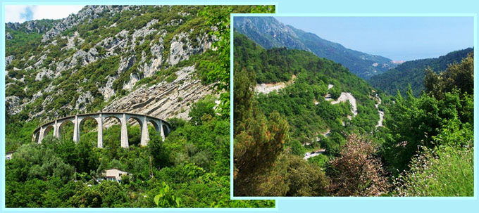 Col du Castillon back to
Cycling Passes in Europe |
|
|
advertisement |
|
|
advertisement |