| |
|
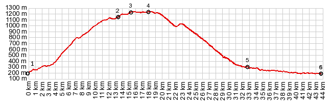
1.(00.0km,0180m)START-END NORTH-1:St
Jean Pied de Port, south gate
2.(13.5km,1140m)jct with D128, and other approaches
from west
3.(15.3km,1230m)Croix D'Urdanasburu marks fork in the
path with Camino Santiago
4.(18.0km,1236m)TOP: Col de Arnosteguy
5.(32.6km,0318m)jct with D301 to Arthaburo s(u)
6.(43.8km,0180m)START-END NORTH-2:St Jean Pied de
Port, same as point 1
|