| |
| |
Tahoe Rim
Trail: Section: Armstrong Pass -
Daggett Pass
This is part of
the TRT section Kingsbury South -
Big Meadow. It contains the
highest point on this section and
I think ialso the most scenic
sections. But the the remaining
part of the section (TRT: Big
Meadow th - Armstrong Pass) is
even more popular with mountain
bikers because of its great trail
conditions.
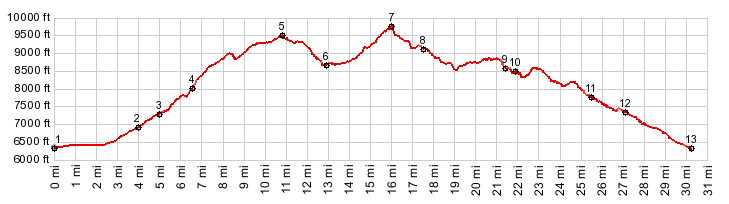
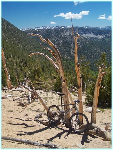
Approaches From South. The direct approach to this part of the trail leads up from South Lake Tahoe up to Armstrong Pass over a popular trail. But one can also ride this summit as part of a fairly long day loop, following the TRT from the Big Meadows Trailhead to Daggett Pass. That's the elevation profile shown above. The description starts at Armstrong Pass. Compared with the TRT south of here, the trail becomes increasingly sandy, but never to the point that would make riding impossible. The trail traverses around the west side of the mountain, mostly gaining elevation steadily and not very steeply. Every once in a while a long straight roll across the wooded hillside makes it feel like you are really making progress in the distance department. Meanwhile the views of Lake Tahoe acquire not only a rugged mountain backdrop, but an additional checkered granite cliff face, that acts as a foreground in pictures. This time, what looks like a top, really is the top. A well defined divide on a flank of Freel Peak (10881ft) is the highest point along the route. On top I met a group of three Truckee bikers with the goal of climbing this highest mountain on the shores of Lake Tahoe, on foot. But the beginning of a late June heat wave made them reconsider. From North. (described downwards) During my ride I underestimated the effort that it would take to get to pavement from here. Yes - contrary to what it looks like from the summit, there is not much climbing left to do, but it's still about 10 miles of sometimes pretty rocky single track to get back to pavement.
A separate Star Lake Trail from the
valley to this sublime spot makes it
possible to divide this section of
the TRT in yet smaller sections with
separate summit points. Surprisingly
the TRT keeps dropping further past
the lake. Then the sandiest section
of the trail so far leads to the
aforementioned saddle. The last
impressive views of Freel Peak all
of sudden give way to the first
panorama of Carson Valley. Somehow I
expected it to look like a bigger
drop, than how it looks from here.
Next comes a walking section
downhill, as the trail appears to
descent into Carson Valley - "oh no,
anything but that. Did I take a
wrong turn somewhere ??" But tire
tracks on the path indicate, that if
I took a wrong turn, many others did
too. Two switchbacks lower and the
trail continues its traverse again,
now firmly on the east side of the
ridge line. In most stretches the
trail becomes easily ridable again,
often the result of extensive trail
building work with supporting stone
walls on the hill side. A few times
I got off the bike anyway, just
because the possible ramifications
of falling off the bike on the
non-hillside seemed too daunting. 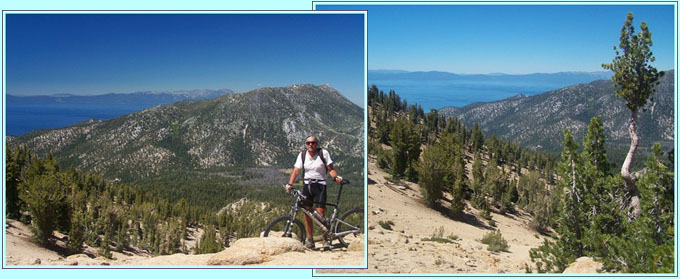 first picture on right: highest point near Freel Peak looking north both pictures above: view towards Lake Tahoe from this summit Eventually Free Peak reappears in
the panorama, showing off its large
vertical drop to Carson Valley.
Finally the trail crosses under a
ski lift and I thought I had it
made. But not so quick - next came
the first truly puzzling
intersection on the entire trail,
where it seems to just end on a ski
run at a 30 percent slope, without a
sign. Choosing the downhill option,
it quickly becomes apparent that
uphill would have been the right
choice. Oh well - nothing that 10
minutes of hard pushing can't fix.
After a while the TRT diverges from
the ski run on the right without a
sign - I think. Now the the trail
contours to the west, but views
between the trees indicate that I am
still looking down into Carson
Valley. But the trail levels out and
becomes increasingly faster. Finally
a few real estate monstrosities of
Carson Ridge (part of the Heavenly
Ski area) become visible, separated
from the trail only by a slight
drop, that appears much higher than
it really is, because of increasing
tiredness. A final great view for
road pass aficionados is the upper
northern approach of the Daggett
Pass Road, as seen from a
rustic bench through a clearing in
the trees. Dayride ( < Luther
Pass | Carson
Pass > ) |
 From the top
it doesn't seem possible to get over
to the next mountain to the north
without another big climb. But the
trail elegantly contours around the
west side of a ridge, that is not
visible from the top, and heads for
the next saddle barely climbing at
all. But first comes a descent to
Star Lake, rocky in places, smooth
in others.
From the top
it doesn't seem possible to get over
to the next mountain to the north
without another big climb. But the
trail elegantly contours around the
west side of a ridge, that is not
visible from the top, and heads for
the next saddle barely climbing at
all. But first comes a descent to
Star Lake, rocky in places, smooth
in others.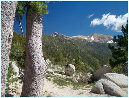
|
|
advertisement |
|
|
advertisement |