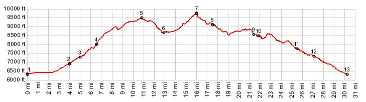
01.(6360ft,mile00.0) START-END SOUTH
ALTERNATE: jct US50 - Ca89, just south of South Lake
Tahoe
02.(6960ft,mile04.0)profile turns left onto sidroad to
trailhead, also jct with Upper Truckee Rd
03.(7330ft,mile05.0) START-END SOUTH: start of Tahoe
Rim Trail at Big Meadow Trailhead
04.(8170ft,06.7mile)jct with alternate approach trail
from further up Luther Pass Rd
05.(9500ft.mile10.9) TOP: Tahoe Rim Trail: section Big
Meadows Th - Armstrong Pass s(u)
06.(97006.(8710ft,mile13.0) low point, immediately
before Armstrong Pass
07.(9740ft,mile16.0) TOP: TRT section Armstrong Pass -
Daggett Pass s(u)
08.(9140ft,mile17.7) intermediate low point at Star
Lake
09.(8610ft.mile21.5) trail crosses from California
into Nevada
10.(8640ft,mile22.0) trail crosses first ski run
11.(7779ft,mile25.5) START-END NORTH ALTERNATE: TRT
trailhead on Stagecoach Express road in ski area.
profile follows road from here
12.(7334ft,mile27.2) profile turns left on top of
Daggett Pass
13.(6330ft,mile30.3) START-END NORTH: jct Nv207 -
US50, north of South Lake Tahoe