| |
| |
Monitor Pass
The two striking things about
Monitor Pass are: 1. It is the perfect vantage
point to get an overview of all the major
ranges and peaks in the area, or as the case
may be: a last goodbye view of all the areas
visited. The second thing, that you can't help
but be impressed by, is the striking
difference between the landscapes to the east
and the west of the pass. To the east: dessert
valleys and naked rock outcrops. During my
visit, background to this scene was a sky ful
of smoke, put there by the burning Pine Nut
Mountains. Descending west of the pass, there
is still plenty of sagebrush, but the high
alpine peaks appear in the distance.
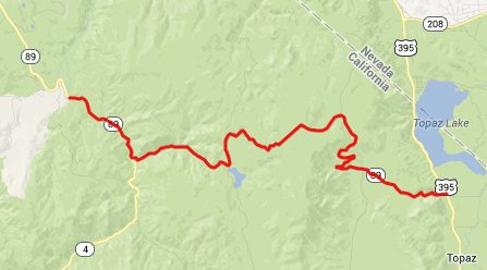
From West. Immediately
south of Markleeville Ca89 reaches a low point,
when it crosses the East Fork of the Carson
River. The road gently follows the creek in a
curvy sagebrush canyon, at times climbing a
hundred feet above it, with scenic view onto the
many fishermen below. In a place labeled Mount
Bullion on maps, the routes split. This profile
goes up the left side to Monitor Pass, while Ca4
keeps following the Carson River to Ebbetts Pass. Ca4 climbs in a canyon filled with
sagebrush and shrub forest. After a good
workout, the road swings up a few far flung
switchbacks and vistas stretching more than 180
degrees. The most striking feature are the two
sets of peaks on each side of Ebbetts Pass: the
ragged ridgeline of the peaks in the Mokelumne
Peaks in the distance to the west, next to it a
higher obtuse triangle shaped peak in the Carson
- Iceberg Wilderness. Then there are the smaller
rock outcrops around Kit Carson Pass.
Long before the road reaches the summit, the
view also stretches north to the mountains
lining the east side of Lake Tahoe. 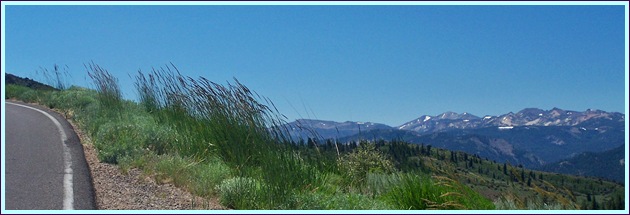
The road reaches for a high point
in the forest. That must be the summit for sure.
But the road has one more surprise in store. It
crosses an inclined plate shaped depression in
one straight line. This summit meadow of sorts
is not an alpine meadow, but still filled with
sagebrush. At this elevation on Ebbetts Pass,
the surroundings would be alpine already, but
you would not have such far reaching vistas. At the summit two pass signs on
each side of the road face each other. One is a
modern generic green sign. The other looks more
like a headstone, containing only the name and
the date of dedication. 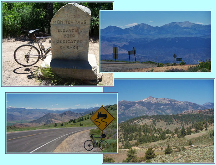
From East. (described
downwards) On this side no trees to get into the
way of far views. The road snakes down in wide,
fast turns. The map labels the rock outcrops to
the north as "Stinking Valley". The road can be
seen far below, still waving snake like through
the dessert grasses. As the temperature has
become much hotter, the road exits into Antelope
Valley through a set of gate like cliffs. During my ride, for some reason I
assumed that I would descend into Carson Valley.
This comes from the simplified view of seeing
the west landscape as an endless, orderly set of
north south running valleys and ridges. But to
my surprise I had to cross another low summit to
get to Carson Valley: the Simee
Dimeh Summit.
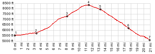
Dayride with this point as
highest summit: COMPLETELY PAVED: ( < Pacific
Grade Summit | Forestdale
Divide > ) History Modern Roads: This pass is
the result of road building in the 1950s, one of
the newest road mountain passes in the Sierra
Nevada Mountains. Before this all the traffic
remained below, following the Carson River into
Carson Valley, barely a detour, compared to
crossing this pass |
 Approaches
|
|
advertisement |
|
|
advertisement |