| |
| |
Forestdale Divide
Many people bike to the Blue
Lakes in the Sierra Nevada Mountains on road
bikes. For them it has to be an out and back
ride. By going over this unpaved divide, one
can make this into a loop and greatly add to
the scenic value.
From South. Near the start
of Blue Lakes Road, a roadside map shows the
entire route across this divide. That map also
names this divide. Blue Lakes Road stays
initially fairly flat. One attraction is the low
traffic volume on this road, much lower when
compared to the Kit
Carson Pass raceway. Soon glimpses of
tempting mountain panoramas appear through the
trees. The crest line of the Sierras is not far
away from here at all, just on the other side of
this green expanse of meadow, that acts as the
perfect stage for the mountains behind - not far
away, and also not that much higher than the
road. The road easily climbs a saddle with a
view downvalley towards Big Meadow, and then
drops a minute amount to the junction with the
access road to Tamarack Lake, which continues
with a mixture of pavement and dirt. Continuing on pavement for now,
the road quickly becomes a service road,
stringing together the PGE campgrounds between
upper and lower Blue Lakes. It was a perfect
summer day when I was here, and the question
came to mind: What is bluer the lake or the sky
? My guess was the color saturation of the lake
was actually higher. Lower Blue Lake hides in
the woods, but the upper lake has a rocky
ridgeline backdrop. The road surface is dirt
between the camping areas, while the campgrounds
themselves are paved. The jeep road up this pass starts
just when entering the last campground. There is
only a forest roadnumber sign, 1N09 I think it
reads. A initially very rocky and steep ascent
(not ridable) soon levels out and gives way to
many ridable sections. A road junction is again
only labeled with number signs. 1N09 continues
on the left. After more climbing, including a
short rolling section, the last view of the
lakes appears. Now seen only through the trees,
the lakes finally take their place in the larger
mountain context they belong in. The jeep trail
climbs above treeline and quickly traverses to
the summit, between a picturesque collection of
dead and live grizzled trees, between low
triangular rock faces and alpine meadows. The
attraction of the landscape is not so much the
size of things, everything is relatively small
when compared to major mountain ranges, but the
picturesque relation in which they stand to one
another. It is like a designed park, with nature
as the designer. The Pacific Crest Trail crosses
the road shortly before the summit. The spot is
marked by small trail signs that are easily
overlooked. The top has remnants of signs, but
none label this divide. 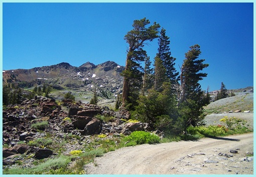 approaching summit of Forestdale Divide From North. (described
downwards). The first couple hundred feet of
drop are very steep and rough. Passing a small
snow field that has lasted till the beginning of
July, the road levels out a bit and curves
between trees and rocks. But more steep sections
are ahead. Approaching the Red Lakes area, this
becomes a good dirt road, with a few extremely
small climbs in the downward direction.
Paradoxically you never see Red Lake from this
road. Looking for this dirt road from
Ca89 to Carson Pass,
the turnoff is labeled as Red Lake. Immediately
after the turnoff the road forks. Going to this
divide, you stay hard left. There is no sign of
any kind at this fork.
PARTIALLY PAVED / UNPAVED ( < Monitor Pass
| Genoa
Peak Road s(u) > ) |
 Approaches
|
|
advertisement |
|
|
advertisement |