| |
|
|
|
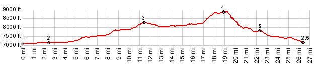
1.(7080ft,mile00.0)START-END NORTH-1: jct Ca88 - Ca89 to Luther Pass
2.(7180ft,mile02.5)START-END NORTH AL-11: jct Ca88 to Carson Pass and Blue Lakes Rd to Forestdale Divide
3.(8300ft,mile11.3) highest point on Blue Lakes Rd
4.(8880ft,mile)TOP: highest point immediately before the Forestdale Divide
5.(7840ft,mile22.4)profile turns right onto pavement on Ca88
6.(7180ft,mile26.5)START-END NORTH-2: same as point2
| |