| |
| |
Genoa Peak Road s(u)
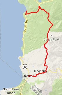
The Genoa Peak Road runs parallel
to the Tahoe Rim Trail, in the section Daggett
Pass (Kingsbury Grade) - Spooner Summit. The road
stays a little higher up on the ridge. But there
still are only a few unobstructed views into the
valleys. For me the major attraction of the this
ride was a short out an back add-on to Genoa Peak
itself.
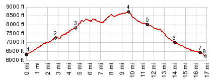
From South. The profile starts at the jct
Ca207 and US50 and climbs up Daggett Pass.
I started the ride at the North Kingsbury Grade
Trailhead, coming up later at point 3, and the
section between points 1 and 3 was the last part
of the ride. Between points 1 and 3 traffic was
heavy, the afternoon hot, and the ride not really
pleasant. When adventurous housing constructs start
overlooking the road, this means that the ski area
is near, and also the summit of Daggett Pass.
The profile turns left onto Benjamin Drive,
quickly becoming Andria Drive. Climbing up through
this suburbia on an incline may be the steepest
part of the entire ride. Eventually the road ends
at the trailhead. The very first part of the
forest road, leaving from here, is also paved -
maybe because it would be impossible to get a fire
truck up this steep grade any other way. As the
road levels out it becomes a little sandy with
waves in it, but still easily ridable. I think the
waves are from the motor cycle traffic. The road
stays near the crest of the ridge, but always
clearly on the west side, never climbing above
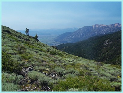
tree line, with a few views of Lake Tahoe and the
Sierra Mtns behind it through the trees. Genoa Peak and the microwave transmission
facility can be seen from the road. The main
turnoff is a little after this view and not signed
in any way. Neither does it seem to show up in
online maps like Google maps. The second part of
the road it too steep and rocky to ride. As I
walked the last part up to the peak, I thought
some motorcyclists had reached the summit before
me, judging from the motor noise coming from the
summit. But actually it was some sort of
generator, that supplied power to the microwave
tower. Continiuing on the road after this short out and
back, the road soon reaches its highest point (not
counting the out and back section to the peak) at
an intersection in the forest, just south of South
Camp Peak. 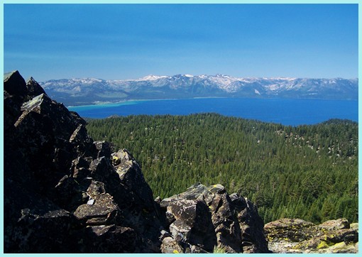 Lake Tahoe and Sierra Mtns from Genoa Peak From North. (described downwards) This
intersection is not shown on the maps that are
often available at the trailheads. The route
looking the most traveled stays left, but dead
ends. So the Genoa Peak Road must continue on the
right, and so it does. Now descending to the east,
there are still hardly any views of Carson Valley.
Instead there are views of real estate office
telephone numbers, nailed to selected trees. Must
be a case of somebody trying very hard to sell
something. At a wood cutting area, the Tahoe Rim Trail
crosses from west to east. Continuing on the road,
my own route lead me eventually to a forest road
with a 4 wheel tractor pulling an entire
semi-truck complete with cab, and truck bed loaded
with wood chips up the the road I was coming down.
Apparently there are some new roads in this area
that are used to remove all the wood chips, that
result from the cutting. By the time I reached
Spooner Summit I was back on the road shown on the
"trailhead map". It comes to within hearing
distance of US50, east of the summit, and then
climbs the last few feet parallel to it, reaching
the trailhead for the Tahoe Rim Trail. The profile
continues on the Spooner Summit Road to Lake
Tahoe. This road, starting at Genoa Peak, does not show
up on Google Maps. But it is on OSM cycle and
HikeBikeMap
Dayride PARTIALLY PAVED / UNPAVED ( < Forestdale
Divide | FR72
Verdi Peak Rd s(u) > )
|
||||||||||||||||||||||||||||||
 Approaches

|
|
advertisement |
|
|
advertisement |