| |
| |
Ute Pass
(Saguache Area)
As the Sawatch Mountains
surrender their height to the vast, high plain of
the San Luis Valley, they terminate with one last
lookout over the valley, Saguache Peak at 10550ft.
A short sidetrip from Ute Pass allows access to a
shoulder of this last grand valley overlook.
Compared with the many twelve thousand foot
Sawatch Range passes to the north, Ute Pass may
seem insignificant. True, the mountains to the
north are a lot higher. But the location of this
pass, at the southern tip of a range, with a
strategic overlook of two valleys, give this pass
its strategic interest.
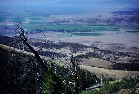
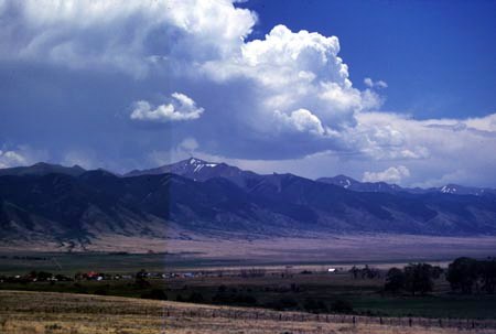
In order to obtain this view, a small additional climb from the top of the pass is necessary. I imagine that at one time the Utes must have valued this strategic view very much. From here you see all movement along Saguache Creek, which leads up to the historically significant Cochetopa Pass. Today the town of Saquache seems to sleep in the valley below.
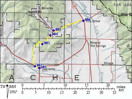
From South. The first dirtroad,
encountered heading west from Saguache on
Co114, is clearly labeled Ute Pass Road. The
smooth dirt road climbs gently and steadily
through pinyon cactus and sagebrush to Juniper
forest country. Good, quiet self-contained camping
is available here. The road climbs to the summit
in a steep bow and the road surface becomes much
rockier. Small powerlines cross the pass summit. The main road continues to the overlook mentioned above, where the strategic advantages are utilized today by a radio tower and microwave transmission dishes. At the transmission facility all views are obscured by trees. But on the quarter mile leading up to it, there are some great views of the San Luis Valley and the Cochetopa Hills. The view of the Sangre Cristo Range is obscured in the center by another forested hill of about the same elevation as Saguache Peak. From North. (described downwards) Because
of the rocks and the steepness on the top of this
side, I think the ordeal of going down is
preferable to the ordeal of climbing. The first
part of the descent is steeper and rockier than
anything on the south side, but still ridable in a
downward direction. The road emerges at a private housing site, that
first looks like a public campground. There is a
"Ute Pass" sign at a critical intersection on this
side, for those heading up. After all that bumpy
braking the best part of the ride just may be the
final miles of perfectly smooth pavement, rolling
towards Villa Grove with the Sangre de Cristos in
the background. This final part is not unlike
descending into San Luis Valley from Poncha Pass, but
Poncha Pass without cars. Also from this side, the
name for the small settlement Villa Grove begins
to make some sense, as one rides past a majestic
grove of Cottonwoods trees lining Kerber creek, a
mile away..
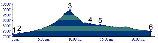
Dayride with this point as highest summit: PARTIALLY PAVED / UNPAVED Ute Pass: partially up 46AA Rd > up
46AA Rd <> out and back to transmission
facility on top of Saguache Peak > down FR852
> down U56 > Villa Grove > US285 south
> sightseeing tour around Saguache > 46AA Rd
back to starting point: 45miles with 3200ft of
climbing (Cateye100A) ( < FR308
Mushroom Gulch Rd s(u) | Bachelor Loop s(u)
> ) same summit point: partially up
46AA Rd > up 46AA Rd <> out and back to
transmission facility on top of Saguache Peak >
down FR852 > down U56 > Villa Grove >
US285 south > 58.EE rd south > US285 south
> 55 Rd south > AA rd west > 54 rd south
> 7 rd west > sightseeing tour around
Saguache > 46AA Rd back to starting point:
48.7miles with 3070ft of cllimbing in 5:37hrs
(garmin etrex30: m3:19.9.12)
|
 Approaches
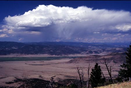
|
|
advertisement |
|
|
advertisement |