| |
| |
Sugarloaf Pass
This is not an officially named
pass or a water divide. The name appears on the
route map for the Leadville 100 mountain bike
race. It refers to the FR105A crossing on the
western and southern flank of Sugarloaf Mountain,
south of Turquoise Lake. The race reaches a much
higher elevation than this pass, but this is the
highest two way summit in the race, meaning that
it has two separate approaches. Since the race is
an out and back race, participants cross this
summit twice. This makes also a great bike ride if
you take your time, possibly even better. The
power line scenery may not be for everybody, but
the riding is great.
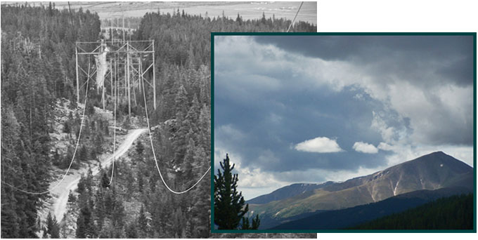
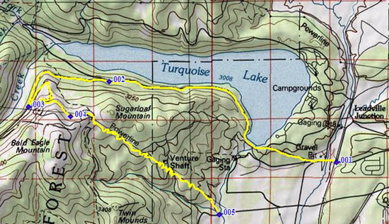 Approaches From North. In order to maximize the elevation gain the profile starts at the low spot between Leadville and Turquoise Lake, just south of a place called Leadville Junction on some maps. The profile shows a direct approach to the pass, following the paved road on the southern side of the lake. The Leadville 100 race follows a longer course around the northern side. The profile turns of the lake shore road onto FR105, also the route towards Hagerman Pass. When FR105A turns off FR105, it doubles back towards the east, and becomes a much less used surface, but very rideable. It climbs up the western flank of Sugarloaf Mountain, together with the Grand Junction bound powerline that comes straight down from Hagerman Pass. The road tops out in a mixture of wilderness and forest harvest area. But there are great Sawatch Range views. From South. (described downwards) Shortly
after the summit a fork appears. To the right is a
distinctive view of Mount Elbert. That's the way
down. But going straight is also recommended. That
option ends under the first power pole and gives a
comprehensive view of the route ahead. After the
initial swerve to the south, a smooth, easily
bikeable, fairly wide path meanders through the
clear cut for the power line, all the way to the
bottom. This may not be post card material, but
the riding is great, and in a country where horses
have more rights than cyclists, I guess it'll have
to do. Just kidding, it is really a nice ride.
There is also a short uphill along the route, and
then the steepest downhill is reserved for last.
The road comes out on a county road north of Co300
at an unmarked intersection, though the duct taped
arrow on the pavement may still be there. The best
way to find it from this side is to head for the
visible powerline cut. From a distance it is
fairly obvious where the powerline comes down the
mountain. The access road is just south to where
this powerline parallels the road. Coming from the
south, you travel on Co300, go by a fish hatchery.
Then Co300 changes number into a county road, then
you crest a small hill with a nice private
residence on the left, and past that voila the
turnoff is also on the left. But obviously going
up the northern side is much easier to find. Organized Rides Personal Dayride with this point as highest
summit: PARTIALLY PAVED / UNPAVED: Sugarloaf Pass , Mineral Belt bike path s(u) , additional out and back: jct FR105 - Turquoise Lake Rd > up FR105 > up FR105A > Sugarloaf Pass > various county roads and Co300 east to US24 <> out and back into Leadville for lunch > Stringtown > Mineral Belt bike path s(u) with several miles of out and backs at intersections > Leadville Junction <> out and back CR48 > CR4 around southern side of Turquoise Lake back to starting point: 48.9miles with 3760ft of climbing in 4:44 hours (VDO MC1.0 m3:11.8.26). |
|
|
advertisement |
|
|
advertisement |