| |
| |
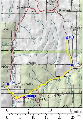
Slumgullion Pass alternate
summit
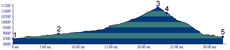
Slumgullion Summit is marked on Co149 between Lake City and Creede on state highway maps. Helmuth's "Passes of Colorado" points out that topo maps place the divide 1/4 mile to the north east on FR788. It identifies the pass as divide between the Lake Fork of the Gunnison to the west and Mill Creek to the east. That is also the route followed by the profile below. Yet other maps are ambiguous about the true location of the pass, placing a name in the general area without accompanying pass symbol.
From East. Before the profile starts,
Co149 crosses Cebolla Creek. This route follows a
dirt road along the creek, instead of Co149, all
the way to the top. Initially the road leads
through a flat bottom valley, rimmed by layers of
caprock that appear to be the perfect natural
fences for keeping in cattle. The valley seems to
contain just as many tourist ranches as real
ranches. Camping in the lower valley is only
practical in a single national forest campground.
After this the road begins to climb and this is
also where the profile starts.Seven miles later,
at the settlement of Cathedral, the road meets up
with Spring Creek and the Los Pinos Pass road.
The route enters national forest land and follows
pleasant open forest land, interspersed with
sporadic wildly shaped rock outcrops to a forested
top. The top is immediately before the junction
with Co149, about 1/4 mile before it reaches its
Slumgullion Summit. From West. (described downwards) Except
for the top 1/4 mile, this side is identical to
the northern approach to Slumgullion Pass,
and the picture below is taken on this side.
A Dayride with this point as
intermediate summit is on page: Slumgullion Pass
History . This separate approach to the
alternate summit of Slumgullion Pass seems like a
very practical historical route at first. The
combination of Pinos
Pass, and the eastern approach along lower
Cebolla Creek, form a direct connection between
the old, well worn Cochetopa
Pass and the top of the alternate
Slumgullion summit, descending into Lake City. In
spite of this the lower Cebolla Creek road
is not a very old route. Otto Mear's toll roads
followed a longer, lower route over Cerro Summit
and Blue Mesa Summit
instead, and then ascending directly to Lake City Besides, the top of Slumgullion Summit was
utilized by Otto Mear's competitor, who had built
a toll road from Del Norte to reach Lake City. The
headwaters of Cebolla Creek (on Spring Creek Pass)
were paralleled by the historic Del Norte - Lake
City toll road, and the name "Cebolla Pass" was
applied to the route prior to the toll road. But
in spite of its name, the route did not continue
to descend Cebolla Creek, but instead Slumgullion
Creek to Lake City. |
 Approaches
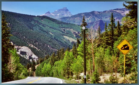
|
|
advertisement |
|
|
advertisement |