| |
| |
Sheephorn Divide
 This is
one of very few divides, that is not mentioned in
Helmuth's book "Passes of Colorado". But it is
marked on old National Forest maps. This seems to
be one of the lesser known passes in Colorado. It
would make the ideal smooth gravel ride, if it
were not for a long stretch of jeep road on the
west side. So let's call it a mountain gravel
ride. The bicycle industry will soon think of a
solution, and create a bicycle specially made for
this dilemma. The route shows off the great
transition between the Gore Range and Gore Canyon,
one name and two mental pictures that are so
different, it took me a while to actually
associate them with each other, and recognize that
they originate from the same person. This is
one of very few divides, that is not mentioned in
Helmuth's book "Passes of Colorado". But it is
marked on old National Forest maps. This seems to
be one of the lesser known passes in Colorado. It
would make the ideal smooth gravel ride, if it
were not for a long stretch of jeep road on the
west side. So let's call it a mountain gravel
ride. The bicycle industry will soon think of a
solution, and create a bicycle specially made for
this dilemma. The route shows off the great
transition between the Gore Range and Gore Canyon,
one name and two mental pictures that are so
different, it took me a while to actually
associate them with each other, and recognize that
they originate from the same person.Judging from the names on my maps, the names Sheep Mountain and Sheephorn Creek (Road) seem to be used somewhat confusingly interchangeable.
From East. Co9 has a wide shoulder between
Kremmling and the signed turnoff onto Spring Creek
Rd. Heading for a mesmerizing peak in the Gore
Range, it makes for a nice paved rolling ride, if
you can tune out the noise of the traffic. Exit the traffic, enter Spring Creek Rd. It
descends a little further to cross the Blue River
between a small settlement of houses. The surface
on this road is the closest thing to paved that
unpaved can be. Looking back, the impression of
the Blue River and its steep semi arrid
embankments is a world of difference from what you
get on Co9. The road climbs in wide well
engineered meanders up a sage slope directly
across from the northern terminus of the Gore
Range as defined by Mt Powell.
FR22 is definitely steep enough to make me walk
substantial parts, without being able to use the
excuse that the surface is too rocky. Near the top
a traverse along the forested ridge gives great
views of Mount Powell. But every time I arrived
here sofar, the clouds have moved in and turned
the landscape into a grey series of outlines. The
top is forested without views, and immediately
afterwards a three way junction meets with CR1831,
the longer way up, as well as the way down the
side, Sheep Mountain Road. This jct is only about
20ft below the summit, not enough for me to
consider it as a separate summit point.
A long superfast decent gets the Colorado ever
closer. What was an open sage landscape containing
the occasional ranch-or-not, becomes a verdant
green canyon with the upper slopes completely out
of sight and mind, as the bike follows wide
meanders between large Cottonwood trees. From the
junction, both summits of Trough Road are between
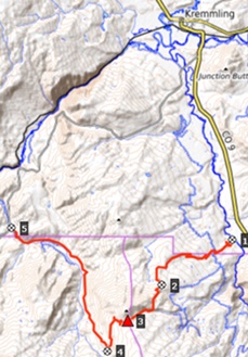
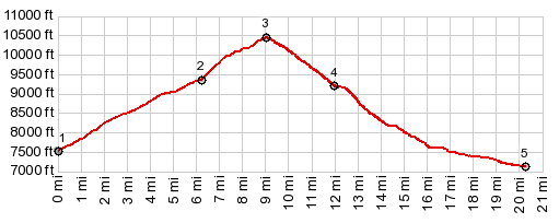
here and Kremmling. 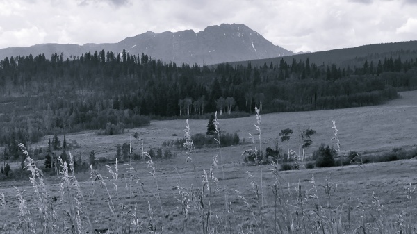 Dayrides with this point as highest summit PARTIALLY PAVED / UNPAVED ( < Ute Pass |
Kaufman Creek
Rd s(u) > ) Sheephorn Divide , Trough Road Pass
, Trough Road s(u): jct CR381 Williams Peak
Rd - Co9 > Co9 north > CR1830 Spring Creek
Rd west > FR22 west > Sheep Creek Divide
> down Sheep Mtn Rd <> short out and back
on Sheephorn Creek Rd south >> Sheephorn
Creek Rd north > Trough Rd east > Trough Rd
s(u) > Trough Rd Pass > Co9 north back to
starting point: 48.4miles with 5390ft of climbing
in 5:58hrs (garmin etrex32 m5:23.08.24) same summit points: jct CR381 Williams
Peak Rd - Co9 > Co9 north > CR1830 Spring
Creek Rd west > Sheep Creek Divide > down
Sheep Mtn Rd > Sheephorn Creek Rd north
<> out and back on Trough Creek Rd west with
probably turn around point near State Bridge
>> Trough Rd east > Trough Rd s(u) >
Trough Rd Pass > Co9 north back to starting
point: 67.7miles with 7130ft of climbing in
6.70dec_hrs (Avocet50 or Cateye: m2:97.8.3) (pics:
dt_41_29-30) 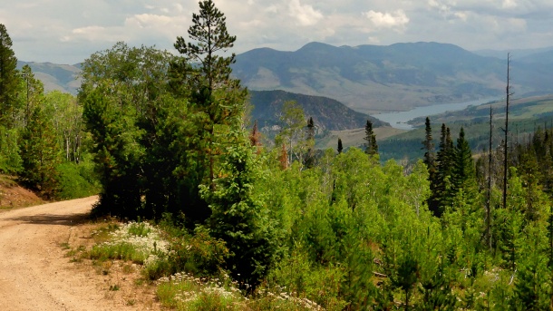 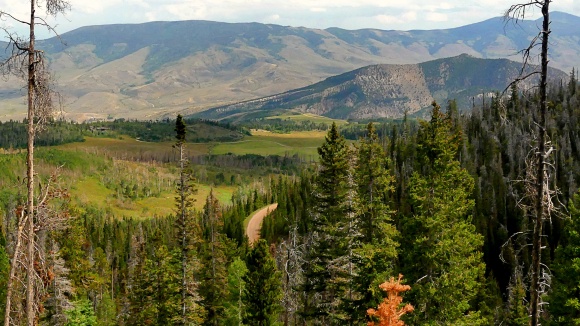 |
 Approaches
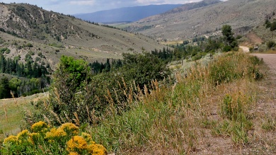 As the
road slowly becomes a hard compressed dirt
surface, it encounters 2 junctions with Spruce
Creek Rd, a kind of forest loop. Continuing, a
short traverse through the forest southwards leads
to a choice of a steep uphill on the right,
labeled FR22. The profile takes this option, but
staying on CR1830 it is also possible to get to
the summit on a longer route.
As the
road slowly becomes a hard compressed dirt
surface, it encounters 2 junctions with Spruce
Creek Rd, a kind of forest loop. Continuing, a
short traverse through the forest southwards leads
to a choice of a steep uphill on the right,
labeled FR22. The profile takes this option, but
staying on CR1830 it is also possible to get to
the summit on a longer route.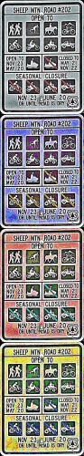 From South. (described
downwards) Instead of a pass marker, the entrance
of Sheep Creek Rd is adorned with a sign,
regulating its access according to 9 different
transportation types, ranging from e-bikes to
hiking boots. It never hurts being specific. It
avoids misunderstandings. This is a jeep road with
all the rocks that belong on such a thing. But in
a downhill direction it is not bad and readily
rideable.
From South. (described
downwards) Instead of a pass marker, the entrance
of Sheep Creek Rd is adorned with a sign,
regulating its access according to 9 different
transportation types, ranging from e-bikes to
hiking boots. It never hurts being specific. It
avoids misunderstandings. This is a jeep road with
all the rocks that belong on such a thing. But in
a downhill direction it is not bad and readily
rideable.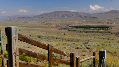 Further
down as Sheephorn Creek comes closer, the surface
is roller coaster solidified hard dirt. The
landscape has changed to a mix of open sage and
pine forest. Suddenly the roller coaster
terminates onto another major dirt thoroughfare,
Sheephorn Creek Rd. The junction may be confusing,
if one is restricted to a 1x1 inch screen of a gps
receiver, or takes advice from the posted map at
the junction. But sense of direction clearly
states that we have to head north from here
towards the Colorado River.
Further
down as Sheephorn Creek comes closer, the surface
is roller coaster solidified hard dirt. The
landscape has changed to a mix of open sage and
pine forest. Suddenly the roller coaster
terminates onto another major dirt thoroughfare,
Sheephorn Creek Rd. The junction may be confusing,
if one is restricted to a 1x1 inch screen of a gps
receiver, or takes advice from the posted map at
the junction. But sense of direction clearly
states that we have to head north from here
towards the Colorado River.|
|
advertisement |
|
|
advertisement |