| |
|
|
|
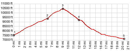
1.START-END EAST: low point on FR1830, immediately after its jct with Co9
2.profile leaves FR831 to climb steeply onto FR1831/FR22
3.TOP, 10440ft, immediately past jct with alternate approach coming up on FR1831
4.profile turns north from Sheep Mountain Road onto Sheephorn Creek Rd
5.START-END WEST:jct Sheep Mountain Rd - Trough Rd
|