| |
| |
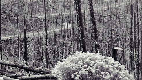
Kaufman Creek Rd s(u) This is a relatively short but
scenic loop, that leads above the southern
approach to Willow
Creek Pass. As of 2023 the road is closed
to motor vehicles and the match stick forest
left over from the last forest fire permits
great views of the Rabbit Ears Range.
The surface here is perfect for a
bicycle. Don't ask me to choose between gravel and
mountain. But there are no rocks, just smooth
compacted dirt. The road curves through the burned
matchsticks, leaving the creek below to the north.
I had to congratulate myself on the weather. Even
though it was still end of August, a dense mix of
thick clouds pierced by the occasional strong sun
ray turned the hills into a canopy of alternating
flat shadows and three dimensional matchscapes.
From North. (described
downwards). The top part is a little rockier on
this side, but nothing that would cause a mountain
bike to slow down. Park View Mountain is a
constant companion, until the road dips back into
the trees for good. The closure gate on this side
is at the junction with Stillwater Pass
Rd. The profile continues down the latter to the
junction with Co125
Dayride with this point as
highest summit
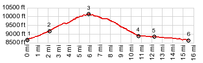
PARTIALLY PAVED / UNPAVED ( < Sheepcreek Divide | Stillwater Pass > ) Kaufman Creek Rd s(u) , Willow Creek Pass x2 : jct Co125 - Buffalo Creek Rd > Co125 north > up FR482 Kaufman Creek Rd > Kaufman Creek Rd s(u) > jct with FR123 Stillwater Pass Rd <> out and back on FR123 east to Illinois Pass trailhead >> FR123 Stillwater Pass Rd west > jct with Co125 <> out and back north > Willow Creek Passx2 << turnaround point at jct Co125 - FR50 at 8990ft >> Co125 south back to starting at jct Co125 - Buffalo Creek Rd: 41.9miles with 3450ft of climbing in 4:51hrs (garmin etrex32 r5:23.08.26) Notes: The loop part of the ride without any addtional out and backs was: 15.5miles with 1580ft of climbing in 2:05hrs - pleasant sun interspersed with clouds and periods of brief heavy rain on the paved parts. The original plan was to stay further south, but it turned out better this way with the rain on the paved section. |
 In thousands of degrees of curature
the road works itself up to a fork.The only
information provided here by a sign is that both
options of the fork will be closed after a mile.
The profile goes left here and then crosses the
closed gate. The closure is not directed to
bicycles.
In thousands of degrees of curature
the road works itself up to a fork.The only
information provided here by a sign is that both
options of the fork will be closed after a mile.
The profile goes left here and then crosses the
closed gate. The closure is not directed to
bicycles. |
|
advertisement |
|
|
advertisement |