| |
|
|
|
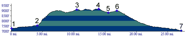
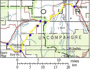
1.(7300ft,mile00) START-END WEST: junction Co62 and Co145 near Placerville
2.(7550ft,mile05) Sawpit, route turns up dirt road turns steeply on left
3.(9110ft,mile11) junction with Last Dollar Pass (road), continue straight
4.(9160ft,mile14) TOP: point of highest altitude
5.(8820ft,mile16) junction with Dallas Divide road. Profile continues right
6.(8970ft,mile17) Dallas Divide
7.(7040ft,mile27) START-END EAST: downtown Ridgway