| |
| |
FR867 Alpine Plateau Road
s(u)
A name like "Alpine Plateau Road"
really sparks my interest. I see switchbacks and
snowy peaks all over the horizon. The road
delivers only on part of this expectation. It is a
great workout. The road is a smooth, unpaved
surface with little to no traffic. However the
views are limited, but there are a few. The road
is fairly close to Owl Creek Pass, at
least as the crow flies. But the pinnacles
surrounding that area remain hidden. Another major
curiosity of this route is a Koch Brothers Ranch
on the north side.
From South. The south side delivers on the
switchbacks. As soon as the road seems to climb
out of the valley it slips into dense foreest and
FR868 crests. There is ample signage at the
intersection iwth FR867, that indicates that you
have to turn right here and keep on climbing if
you want to eventually get to US50. The road
remains as smooth as before. It seems to crest at
the edge of the plateau, but rolls along and
reaches a high point a few miles later. There is a
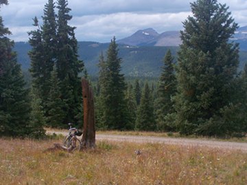
good view of the Uncompaghre / Wetterhorn area
right before the highest point of elevation, and a
better view from a spur road onto a summit meadow,
right after the high point. From North. (described downwards) This
side has a different character. It is a forrest
road, following gentle ravines all the way down.
The surface here is sometimes sandy, so that it's
easier to just roll down through it. The lower 8
miles are under the private control of
industrialist Bill Koch, a major financial
contributor to the republican party. Apparently he
is building his own "wild west town" here for
storing his collection of military vehicles. He is
also accused of cutting of public access to
grazing areas and wilderness areas that were there
for decades before him. There is also another
bizarre story of a fellow executive held hostage
on this ranch. As an aside, The "Koch Problem" is
also a major reason, why Americans can't seem to
agree on the fact that global warming really does
exist. From this unpleasant spot, it is as fast a
descent, as one is ever going to have on a
mountain bike on an hard medalled road. You just
have to watch for the traffic. There is more of it
here below the Koch Ranch. There is a picnic bench
hidden in the woods at the junction with US50 if
one hasn't had time for lunch yet. The profile continues on US50 over part of the
eastern Blue Mesa
Summit approach to seek out a low point
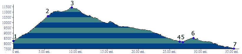
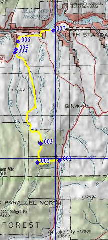
where it crosses a bay of Blue Mesa Reservoir. Dayrides with this point as highest summit: FR867 Alpine Plateau s(u), CR26 Lake City Cutoff s(u): Upper part of CR26 > CR26 Lake City Cutoff s(u) > Co149 south > up FR868 > FR867 Alpine Plateau s(u) > down FR867 > US50 east > Blue Mesa Reservoir > up CR26 Lake City Cutoff > back to starting point: 71.3miles with 6100ft of climbing in 6:20hours (VDO MC1.0 m3:11.9.10).
|
||||||||||||||||||||||||||||||||||||||||||||||
 Approaches
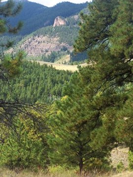
|
|
advertisement |
|
|
advertisement |