| |
| |
Corkscrew Pass
In a previous version of this
page, I wanted to call these slopes metamorphosed
rainbows ... a colorful light vision on stone.
These days a less flowery style is called for.
Still ... streaks of red oxide run in straight
lines down slopes, complementing jagged ridge
outlines in the background. This part of the San
Juan mountains have the color of the canyons, that
start to dominate the landscape west of here. Even
the Weemenuchi Wilderness cannot match this area
in sheer rainbow technicolor quality. But then
again, this area could never match that wilderness
in pristine quality. The same color that makes
this area so visually exciting, attracted more
practically oriented citizens, miners looking for
gold. As a result there are just as many streaks
of red oxide running off old tailing waste piles
as from natural slopes.
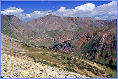 One of
these mining areas, characterized by big mountains
and big mine tailings, is centered around
appropriately named Red Mountain Pass
between Silverton and Ouray. Corkscrew Pass offers
one of the better vantage points on this area. The
proximity of three unpaved passes, California Pass,
Hurricane Pass
and Corkscrew Pass, make a trek across any number
of them a prime objective for a dayride that stays
above treeline for a substantial time. The Hurricane Pass
page contains more pictures from such a ride. One of
these mining areas, characterized by big mountains
and big mine tailings, is centered around
appropriately named Red Mountain Pass
between Silverton and Ouray. Corkscrew Pass offers
one of the better vantage points on this area. The
proximity of three unpaved passes, California Pass,
Hurricane Pass
and Corkscrew Pass, make a trek across any number
of them a prime objective for a dayride that stays
above treeline for a substantial time. The Hurricane Pass
page contains more pictures from such a ride.Corkscrew Pass is high, short and steep in equal proportions, the very shortness effectively making it yet steeper. Unlike the historically significant unpaved passes in the San Juans like Cinnamon Pass, Engineer Pass and others, this is not an endurance event, but more of a strength contest, strength that is required to push the bike up a good portion of the very steep route. Unlike the other two passes in this area, Corkscrew Pass is not marked by a sign on top. Neither is it marked on topo or National Forest maps. It is referred to by name on a sign on the eastern approach. "Passes of Colorado" also identifies the pass and sources it to "local usage".
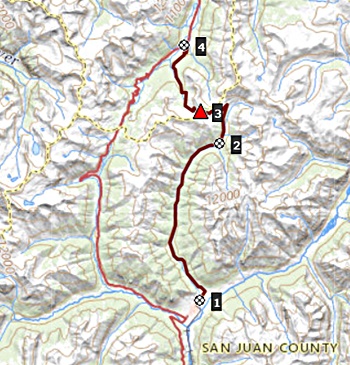
From Nort. (via Corkscrew Gulch) The
dirtroad trail to the pass leaves US550 (the Red
Mountain Pass road) in the ghost town of Ironton
Park. The route is signed as county road 20. The
initial climb up Corkscrew Gulch is smooth and
ridable. The second part of the climb starts at a
bowl that contains a meltwater lake during the
spring. At this point the climb becomes too steep
to ride, or maybe it just seems like it to me
after the initial effort. The top is in rocky
tundra with incredible views in three directions,
Red Mountain No.3 to the west, vertical peaks to
the south and the trace of Hurricane Pass ahead
towards the north. The double track heading towards Red Mtn No3 ends
after a while, but not before delivering some
incredible views. Some of the pictures are from
this short out and back detour. The map apparently
shows a trail connection with Red Mtn No 3 (?). From South: (also described upwards) The
county road from the east end of Silverton is a
wide and well surfaced, unpaved highway. At the
American Tunnel Mine the track becomes etremely
steep with scenery to match. An alternative second
route stays lower in the valley and further west. At this junction Cement Creek Rd with the route coming down from Corkscrew Pass, used to stand a sign naming Corkscrew Pass. On my last visit it had been removed. The view of vertical Tower and Dome Mountains from starting about here and points up, make this one of my favorite scenic spots in the San Juan Mountains. Apparently others like it too, because a well constructed out house has been erected in the vicinity, detracting somewhat from the natural qualities. However if out houses are needed, they need to be built, and built it was.
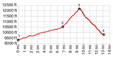
Dayride with this point as
highest summit: PARTIALLY PAVED / UNPAVED: ( < Red Mountain No3
Rd s(u) | ) Corkscrew Pass , Red Mountain Pass
, additional out and back: a short distance
north of jct US550 to Red Mtn Pass - South Mineral
Creek Rd > US550 south > SIlverton with
sightseeing detours <> out and back up CR33
to a turnaround point where it turns up the
mountain >> CR110 north > Corkscrew Pass
> CR20A north > UAS550 south > Red
Mountain Pass > back to starting point on
US550: 33.3miles with 4610ft of climbing in
5:16hrs (garmin etrex30 m5:21.7.6) A Dayride with this point as intermediate
summit is on page: California
Pass 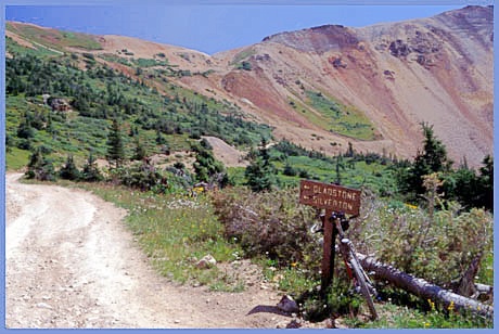 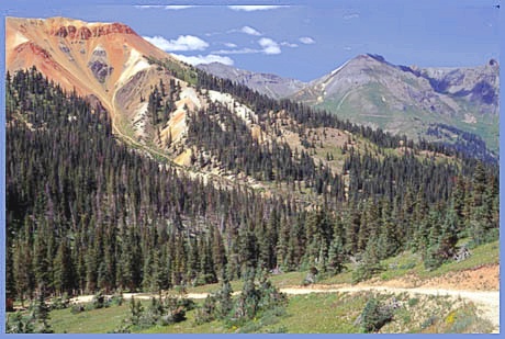 History Cycling. An early mountain biking guide, first published in 1987 listed the Corkscrew Gulch and Cement Creek approaches and as being suitable for mountain biking in its appendix, without describing them any further (William L. Stoehr's: Bicycling the Backcountry). |
 Approaches
|
|
advertisement |
|
|
advertisement |