| |
| |
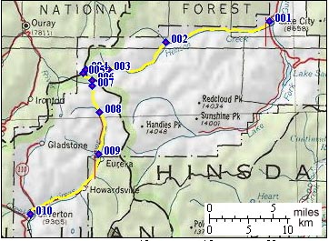
Engineer Pass
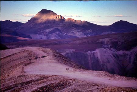
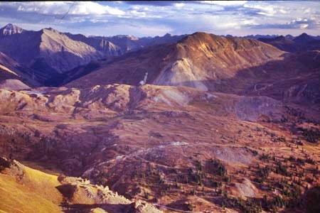
There are actually two Engineer Passes. The old original one is located at point 4, and also often called North Engineer Pass. The modern road touches that point and climbs a little higher to the summit point described here, also called South Engineer Pass or Ivonne Pass. This is the highest point on the "Alpine Loop" circuit, which also goes over Cinnamon Pass. The landscape here is unique because of the Molas Caldera, a big volcano that exploded many moons ago, and left a set of high plateau like surfaces with peaks sitting on top of them.
Approaches From East. The turnoff to
Engineer Pass is near the southern end of the
Lake City business district. At the corner is a
cafe named the Confluence, where Brit
specializes in restoring deraileurs to a
functional state, many of which have impaired
functionalty, because of the rocks on the nearby
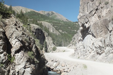
Colorado Trail. The lower part of the Engineer
Pass road is a smooth hard surface. It follows a
small and narrow narrow incised canyon, carved
by Hansen Creek into a vertical lava layer.
Remnants of mill buildings, belonging to Lake
City's major historic mine, flank the lower part
of the road. Past that the road passes two
signed jeep trail turnoffs to trailheads of
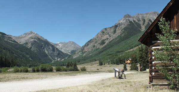
"14er peaks" Uncompagre Peak and Wetterhorn. At one point the valley widens and
vertical mountain peaks enclose a picturesque
grassy park. It makes sense that this would also
be the historic site of the mining town Capital
City. There is more room here - and what a
magnificent setting. A few picturesque old
looking ( and therefor small) .wood structures
remain. But they look slightly out of place
surrounded by a forest of real estate agency
signs, and two or three displays of modern
otstentaciousness, when it comes to private
buildings. Signs indicate, that In modern times
of climate change this wonderful large meadow
also searves as "Temporary Wildland Fire Refuge
Area". The road to the pass diverts
before the western end of this idyllic park. A
sign shows the way and indicates that the road
is going to become rougher, and for motor
vehicles 4 wheel drive is recommended. A rocky
road with variable rolling slope finally breaks
out above treeline, On the other side of the
valley a water fall tumbles down in a string of
water. Its source above is out of view. The last section starts, again
with a drastic crease upwards in the road. The
area of transition is known as "Rose Cabin", and
I don't think this refers to the modern vacation
cottage that stands there today. A hike to the
north quickly leads above treeline and onto the
high surface of the old Molas Caldera. From up
there the local 14ers and Matterhorn look like
encrustations on top of petri dish. The road now continues in steep
switchbacks up the lower side of Engineer
Mountain, and for me walking my bike becomes the
norm instead of a common exception. There are
several false summits above treeline before
North Engineer Pass is reached. On the other side the viewshed not
only includes Uncompahre Peak and company, but
also the enitre San Juan Range west of Siverton.
They form a unque set of high mountains,
comprised of multiple pedestals, [1] upon which
sit peaks and more pedastals, up which .. go to
point [1]. This is the original Engineer
Pass. Today books refer to it also as Yvonne
Pass or North Engineer Pass. To find the
original steep descend on the west side into
Ouray you have to look harder than some books
would indicate. Today's popularly traveled route
travels another 170ft higher and continues to
around the northern side of this mountain, and
reaches a highpoint at a short turnoff to a spur
road, labeled with the sign Oborn Point. No idea
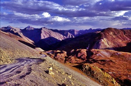
who he is. From West. (described
downwards). The upper descend of South Engineer
Pass has the best continued views along the trip
because of its exposure above treeline and a
spaghetti salad of switchbacks below,
backgrounded by mountains of different character
and forms. It is actually difficult to believe
that this part of the descent only looses about
900ft of elevation. But then the track has
parts that climb a little bit along the descent. At the bottom is a junction. The
"Alpine Loop" sign at this spot allows different
interpretations on which way "the loop"
continues. Going right goes to Ouray via Mineral
Creek. The lower part of this road has some
incredibly rough and rocky sections.
Further down an incredibly steep
road below a face of Handies Peak (14048ft)
comes into view. Please let this not be the
route to Cinnamon Pass, ie the route back to the
other side of the Alpine loop. It is not. The
actual turnoff to the Cinnamon Pass
does not come into view before a quarter mile of
reaching it. The beginning is torn up, rocky and
steep that it leads to doubts about the general
course of civilization. But this profile continues
downwards towards Silverton instead. A few
hundred feet lower lies Animas Forks, one of the
most extensive collection of old mining remnant
buildings, ruins and historic garbage in the San
Juan Mountains. Below here real bicycling
becomes more feasible again. Soon a good dirt
road leads through a majestic valley all the way
into Silverton
Dayride with this pass as
highest summit: PARTLY PAVED / UNPAVED Engineer Pass , Cinnamon Pass :
somewhere between Silverton and Eureka >
Animas Forks > Cinnamon Pass > Lake City
> Capital City <> out and back detour
because of a wrong turn >> Engineer Pass
> Cinnamon Pass Cutoff(shp) > Animals
Forks > back to starting point between
Silverton and Eureka: 73 miles (mech
Odom1:91.9.26) [pics:t91`_6]
same summit points: just
outside of Lake City > Capital City >
Engineer Pass > Cinnamon Pass Cutoff >
Cinnamon Pass > back to starting point in
Lake City: 50.6miles with 6120ft of climbing in
7:3hrs (garmin etrex30 m5:18.5.30)
History The Leadville Mining Boom (<Slumgullion/Spring
Creek Pass|Denver Hill
-1(sh)>): It is the time when
the Leadville mining boom reached into the San
Juans, In 1877 the towns of Silverton and Ouray
already existed, but Lake City was the real
center of activity. The mines of Mineral Point
were really closer to Ouray. But in order to
serve them from Lake City, Otto Mears
constructed a toll road over Engineer mountain,
following the route of today's North Engineer
Pass. Considering today's torn up road it is
difficult to picture, yet true, that not only
freight wagons and Mule teams used the old North
Engineer Pass crossing, but in 1880 even a daily
stage coach between Lake City and Animas Forks.
Cycling. An early mountain
biking guide, first published in 1987 mentioned
Engineer Pass as being suitable for mountain
biking in its appendix, without describing it
any further (William L. Stoehr's: Bicycling the
Backcountry). - |
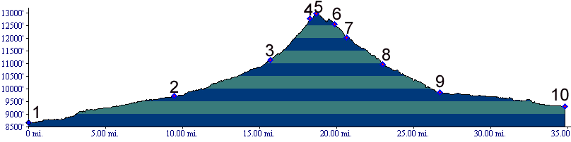
 Instead the profile stays left
on a relatively short connection - at least it
seems that way in a downward direction, compared
to what went before. This is known as the
Cinnamon Pass cutoff. This seems like a low
shoulder point, compared to the surround peaks
and passes, but it is actually at around 12000ft
in elevation. Marshall Sprague in "The Great
Gates" also attaches the name "Denver Pass" to
the nearby high point. It is actually a short
distance away from the profile, direction
Mineral Gulch and Ouray. No other sources seem
to use this designation. Both Marshall Sprague
and other sources identify (a second) nearby
Denver Pass, located on the adjacent ridge
separating Cinnamon and Engineer passes. But
there are also two possible nearby road shoulder
summits in the area: See Denver Hill -1 and
Denver Hill -2
Instead the profile stays left
on a relatively short connection - at least it
seems that way in a downward direction, compared
to what went before. This is known as the
Cinnamon Pass cutoff. This seems like a low
shoulder point, compared to the surround peaks
and passes, but it is actually at around 12000ft
in elevation. Marshall Sprague in "The Great
Gates" also attaches the name "Denver Pass" to
the nearby high point. It is actually a short
distance away from the profile, direction
Mineral Gulch and Ouray. No other sources seem
to use this designation. Both Marshall Sprague
and other sources identify (a second) nearby
Denver Pass, located on the adjacent ridge
separating Cinnamon and Engineer passes. But
there are also two possible nearby road shoulder
summits in the area: See Denver Hill -1 and
Denver Hill -2|
|
advertisement |
|
|
advertisement |