| |
| |
Colorado Trail m374.2:
Spring Creek Pass - Wager Gulch s(u)
The vast majority of this section of
the Colorado Trail is above treeline, and it also
contains the highest point of the entire Colorado
Trail. This section follows an alpine escarpment
of the San Juan Mountains on the southern end of
the Molas Caldera. The profile contains at least three
additonal separate summit points, ie points that
can be approached separately with a minimum of
500ft elevation gain on both sides.
From the trailhead at the top of the pass a
nicely rideable dirt road heads south. Then a
single track with lots of rocks carves a way
through willows and brush, following the La Garita
Stock driveway. The top of the first mesa is a
summit in its own right ( page Colorado Trail:
m363.1 Spring Creek Pass - BLM3323 s(u) ).
The trail cuts across the flat Jarosa Mesa in a
straight line, a faint track connecting cairns,
that would still show up in large snow drifts.
There are no trees here whatsoever. So the cairns
have nothing to compete for to get attention,
except for the horizon, which is a formidable
competition. Uncompahgre Peak is many miles away.
But its curious shape, stands out over the
landscape like a small curious vase on a table
top. The descend from Jarosa Mesa to a four way
junction is much smoother and fun to ride than the
previous section. This is where the approach form
BLM3323 meets the profile. Another nearby right
option leads to the plainly visible transmission
facility on the hill. The left option does not
show up clearly on my maps. And the Colorado Trail
continues straight, climbing on an old ranching
track, that is more quickly rideable than the
miles on Jarosa Mesa. The trail heads for the edge
of the escarpment ahead. At this low point the CT
virtually touches the edge of the cliffs and gives
the best view up the lower valley of the Lake Fork
towards Cinnmon Pass.
For the remainder of the way to the top, the CT
stays well away from the edge of the escarpment.
Just past this point, the CT turns back onto the
escarpment for a short rocky climb that has to be
walked. At the top waits a second possible summit
point at m366.0. 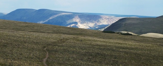 From the top of the summit point at m366.0 the
plateau ahead can be seen as a series of large
monolithic steps upward, that hint at the energy
that is going to be necessary to climb them. The
vista does not corroborate the fact that the trail
will climb to the top of each one. The trail is
not easily visible from here. So you could assume,
that it skirts around the tops. But in reality it
does get close to the top of each of these steps
in a roundabout way. At the next low point a
ranching track appears to offer another way to
connect with the trail from the south. Again this
option does not show up on my map. The impression of the landscape now is a vast
flowing tundra plain, curving away to the distant
high peaks of the Eastern San Juan Mountains. But
next comes is a rare remaining section, comprised
of a single track through dense forest. This next
step in the landscape after that would take most
of my energy. It is the steepest and rockiest
part, to what I hoped would be the top. Pushing my
bike up this steep rocky slope, a hail storm was
starting to make, what felt like dents on my head.
It was not the top. After that, the two
remaining intermediate high points look very
impressive in photographs and in real nature. They
carve a traverse across stark bowls of tundra. But
effort wise they not very steep, and are separated
by less than a 200ft in elevation drop. From the
second traverse you can finally see the way down
into Wager Gulch, even it is still many calories
away. The last final climb is a little bigger again and
aims for a hardly discernible saddle on a gentle
flat bread loaf. At the top a sign marks the
highest point on the Colorado Trail. A huge
viewshed to the north opens up.
As a profusion of signs direct the traveler to
turn left and stay on the CT on yet another jeep
track, this profile elects to stay on the unsigned
road down into the valley. Branter Gulch is a
steep, except for the bottom not-too-rocky jeep
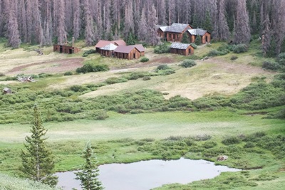
track. At about treeline a handfull of decaying
wood houses on a pond are in reality the old
mining camp Capitol. All in all, this road would
be a tough slog on the way up. Dayride with this point as highest summit: PARTIALLY PAVED / UNPAVED ( < Engineer Pass
| Dallas Trail:
section Dallas Rd - West Dallas Rd s(u) >
) Colorado Trail m374.2 s(u) : Spring Creek Pass
- Wager Gulch , Colorado Trail m366.0
s(u) , Colorado
Trail m363.1 s(u) :Spring Creek Pass - BLM3323
, Slumgullion
Pass : jct FR788, 1.4 mile north of
Slumgullion Pass > Slumgullion Pass > Spring
Creek Pas(shp) > Colorado Trail west >
Colorado Trail m363.1 s(u) > Colorado Trail
m366.0 s(u) > Colorado Trail m374.2 s(u) >
down Wager Gulch Rd > Cinnamon Pass Rd east
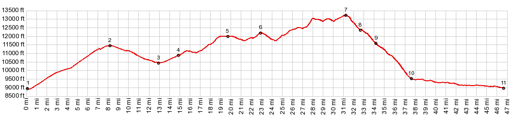
> Co149 south back to starting point: 47.0miles
with 7120ft of climbing in 8:02hrs (garmin etrex30
m5:18.7.8) 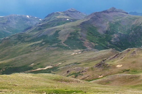 |
|
|
advertisement |
|
|
advertisement |