| |
| |
Limestone Mountain Road
s(u)
This is a two way summit with an
optional out and back to the top of Limestone
Mountain. The two way summit has two very
different approaches. One is a good, fast gravel
road with enough matriculated rocks to be usable
in pretty much any weather. The options on the
other side either dead end or in the best case
lead back to pavement to form a loop, using barely
used, hardly rideable, difficult to walk ranching
tracks in many places.
It is not. Continuing on Limestone
Road, a gradual steady climb on well matriculated,
somewhat rocky gravel road quickly exposes the
error of the initial assumption. From up here you
can see clearly that Wy28 too keeps on climbing to
about the same elevation. Any vistas of peaks in
the high Wind River Range are very limited. A
turnoff up to the top of Limestone Mountain,
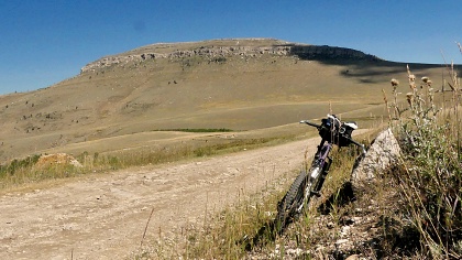
labeled as some sort of parking area, looks much
more promising in that department. Two of the
pictures on this page are from that road, but only
a few hundred feet distant from the junction with
the profiled Limestone Mtn Rd. The road summits at
a traverse in the trees.
After this the profiled road surface
takes a big dive, figuratively speaking The next
jct is only labeled with two numbers: FR353 going
north and downhill or FR326, heading direction
somewhat closer to pavement and civilization.
FR353 descents to a low point at a crossing of the
Little Popo Agie River. There is no bridge, but in
September the water is not very high. I have not
tried the trail that attempts to climb out of this
basin on the south side, but it looks like it
might take forever. The decent down to the Little Popo
Agie is not included in the profile, but it is
part of the loop in the dayride below. The profile
climbs up the next summit on the original gravel
road at the jct to FR326. The
description continues on that page.
Dayride with this point as
highest summit:
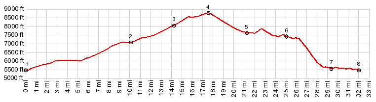
( < Green Mtn Rd - Mine Acess Rd(sh) | FR300 Louis Lake Rd s(u) > ) Limestone Mtn Rd s(u) , FR326 s(u) : upper jct of Red Canyon Rd - Wy28 > up Wy28 > up Limestone Mtn Rd > Limestone Mtn Rd s(u) > jct FR352 - FR326 <> out and back down FR352 << turnaround point at lowest point where it crosses Little Popo Agie River > FR326 north > FR326 s(u) > FR326 north > down unmarked track some distance north of canyon of Little Popo Agie River > Red Canyon Rd north > Wy28 south back to starting point at upper jct of Red Canyon Rd - Wy28: 36.5miles with 4570ft of climbing in 5:51hrs (garmin etrex32 23.09.06) Notes: I don't remember 36 miles being this hard. But admittedly, there was a strong headwind on the way back up Wy28 towards South Pass, and coming down FR326 s(u) involved a lot of walking. |
|
|
advertisement |
|
|
advertisement |