| |
| |
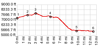
FR326 Wind River foothills
s(u)
The only reason for the exisitence
of this page is because it happens to be the
summit that has to be crossed, when making a loop
over Limestone
Mtn Rd s(u). This summit is unusual in that
the most obscure and difficult sections are at the
bottom, while going across the top is a relatively
wonderful experience.
From the junction with Limestone
Mountain Road, the surface surface following the
profile is new and improved, even if very bumpy. A
short climb leads to a summit on a traverse with a
fairly nice view back to the Wind River Range. From East. (described
downwards) As a general rule for this approach,
the further down you get, the worse it gets. The
track heads northwards. But it can't get across
the canyon carved by the Little Popo Agie. So the
profile turns right across a gate, following the
route most traffic has followed.
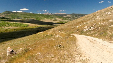
Looking back up from the bottom,
after the torture has ended, down here it is an
idycllic location, made up of a few small
farmhouse at the mouth of Litte Popo Agie Canyon.
It stands in contrast to the squiggly line down
the vertical wall of grass that I just came down.
The only thing worse would be going up this same
slope. For the grand finale the route has to cross
a deep watering ditch between the field and the
road. But wait - there is a wooden plank laid
across the watering ditch. The road turns out to
be the Red Canyon Rd, a parallel gravel
alternative to the lower eastern approach to South Pass. The
spot where the torturous descent ends is easy to
recognize in the other direction, because of the
remnants of an old house (picture included), also
the adjacent bridge across the Popo Agie. The
profile continues downvalley on the Red Canyon
Road to its junction with Wy28.
|
 Very soon this becomes an
extremely rough and rocky ranch track, that makes
even walking uncomfortable. After one more climb
up a small hill, the only comfort is the view of
ranches down in the valley, which signal an end to
this torture. After a steep descent on what I am
tempted to call a mountain face made up of range
land, the recorded profile cuts across some fields
to get to the road that had been visible from
above.
Very soon this becomes an
extremely rough and rocky ranch track, that makes
even walking uncomfortable. After one more climb
up a small hill, the only comfort is the view of
ranches down in the valley, which signal an end to
this torture. After a steep descent on what I am
tempted to call a mountain face made up of range
land, the recorded profile cuts across some fields
to get to the road that had been visible from
above. 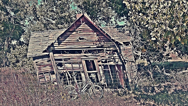
|
|
advertisement |
|
|
advertisement |