| |
|
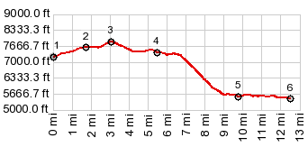
1.START-END WEST:FR326 crosses Little Popo Agie River without bridge
2.START-END WEST-ALT: jct FR326 - Limestone Mtn Rd
3.TOP, 7850ft
4.route crosses gate, direction west, before reaching canyon of Little Popo Agie
5.jct indistinct trail - Red Canyon Rd
6.jct Red Canyon Rd - Wy28
|