| |
| |
Rat Trap Pass
This is a rare opportunity for an
actual day loop ride over a named pass in the
Cascades. In spite of the 3000ft elevation gain
the road stays in deep forest and offers only a
few glimpses of the giants above. For me the main
attraction is the deep mossy forest.
Initially the road is a smooth surface and
follows the White Chuck River. After crossing onto
the north side the surface becomes more rocky, the
climb intermittently steeper and the forest
remains as impenetrable as before. The main reason
for this road seems to be the Meadow Mtn
Trailhead. Past that the road takes another step
down in maintanance and ridability.
From North. (described
downwards) On one of the wide meanders there is an
actual view of a mountain towering above, giving
at least a hint of the landscape above (picture to
the left). The profile stays left at every
intersection. None of these have any signs, but
the left always goes downhill. The deep peaceful
forest on this side, with its copious amounts of
moss hanging on every branch, to me is the most
impressive aspect of this summit. After a narrow
bridge over the Suiattle River, the route turns
left onto the paved Siuattle River Road and
continues in peace with a few views of snow capped
peaks through the trees, to the jct with Wa530,
which leads back to Darrington.
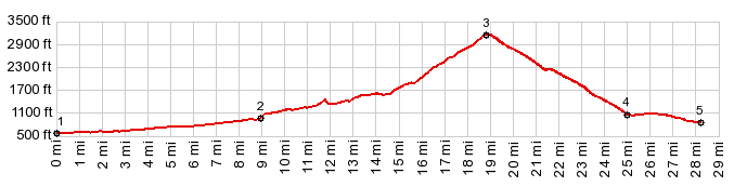
Dayride with this point as highest summit: PARTIALLY PAVED / UNPAVED
Rat Trap Pass , additional out and back :
jct Mtn Loop Highway - FR to Mt Pugh Th <>
out and back on Mtn Loop Highway as far as Bedal
Campground >> Mtn Loop Highway north >
FR24 > Rat Trap Pass > down various unmarked
forest roads as shown on map <> out and back
on one of these with turnaround point a mile or so
beyond Darrington Seat Orachard >> down more
unmarked forest roads > Siuattle River Rd south
> Wa530 south > Darrington > Mtn Loop
Highway south back to starting point: 65.5miles
with 5010ft of climbing in 6:35hrs (garmin etrex30
m5:17.8.25
|
 A short distance below
the top nature has helped the National Forest
Service's aims by washing out the road. This saves
them the work of closing down yet another road to
through going traffic. But to make sure forest
service erected extra barriers on each side.
Fixing the road would probably have been less
work. Luckily a bicycle can easily get through all
these obstacles easily. The top is a long straight
road in the forest.
A short distance below
the top nature has helped the National Forest
Service's aims by washing out the road. This saves
them the work of closing down yet another road to
through going traffic. But to make sure forest
service erected extra barriers on each side.
Fixing the road would probably have been less
work. Luckily a bicycle can easily get through all
these obstacles easily. The top is a long straight
road in the forest.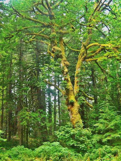 ( <
( < |
|
advertisement |
|
|
advertisement |