| |
|
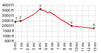
1.(00.0m,2400ft)START-END EAST:low point, just past jct: Stampede Pass Rd - I90
2.(00.9m,2500ft)Iron Horse Trail crosses Stampede Pass Rd
3.(04.1m,3680ft)TOP: Stampede Pass
4.(09.2m,2000ft)jct with FR50 on right, a possible loop
5.(12.8m,0770ft)STOP-END WEST:road closed, just after jct with FR53
|