| |
|
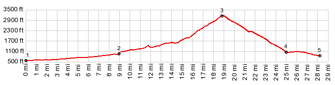
1.(00.0m,0560ft)START-END SOUTH: jct Wa530-Mountain Loop Hwy, Darrington
2.(09.0m,0980ft)profile turns left onto FR23
3.(18.8m,3170ft)TOP: Rat Trap Pass
4.(25.0m,1060ft)jct with FR25
5.(28.2m,0840ft)START-END NORTH: bridge over Siuattle River and jct with Siuattle River Rd
|