| |
| |
Junior Point / Shady
Pass
This road crosses the high,
pretty much unbroken ridge line of the Chelan
Mountains. This range looks almost like a big
plateau. But there are distinct summits here.
The east side is drier and also more fire
ravaged, giving the area an open feeling with
great views. The west side is deep Cascade
forest. Here orientation and views resemble the
situation of a bug crawling around in a thick
shag carpet.
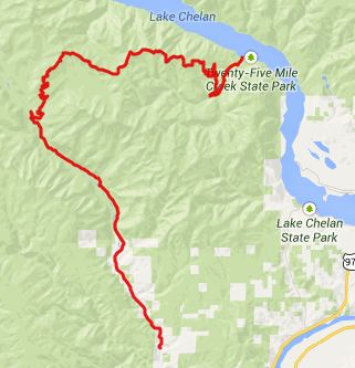
From East. FR59 puts and end
to the vacation meanders of South Lakeshore Road,
on Lake Chelan. It climbs steeply above the lake,
twisting and turning like a real mountain pass
road. The pavement ends at the juntion with Slide
Ridge Road. Shady Pass Road steeply ramps
itself up the south facing slope. The views of
Lake Chelan keep getting better. In the morning
they are flatly lit from the front, and there is
not much shade. But it did make me look forward to
some possible shade on the pass. But the pass, at
this point, is still very far away. After a last great view of the lake,
the road traverses and meanders towards the ridge
on its north side. Meanwhile an apocalyptic
looking match stick forest has taken over every
slope, mountain and ridge line in sight. But in my
opinion it still looks more appealing than a clear
cut pattern, which you see so often in
northwestern forests. After reaching an
intermediate high point the road ahead can be seen
stringing along, hopping over to the next peak, i
regluar arcs like a telephone line. To the north a
high ridgeline in the North Cascades becomes
visible for the first time. Lake Chelan makes
another appearance, deep below, behind a curtain
of matchstick forest. It's reasonable to expect the next
traverse to be the top. After all no higher points
are visible along the ridge, at least not until
you get to it. But it's getting closer. And the
best views are from shortly before the top. The
highest point along the road is signed as Junior
Point. There is a campground here and a rest room
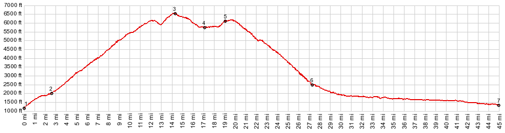
inside a yurt. 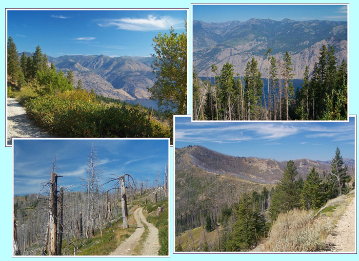 From West. (described downwards) Progress from here on becomes dramatically faster, even if Shady Pass is not reached yet. A long traverse, with just enough drop to make Shady Pass a separate summit connects Junior Point to the pass. Right about here the matchstick forest ends and a deep, endlessly green tree groundcover takes over. There is no view from Shady Pass, but there is a sign, and the road goes over slightly higher points before and after the pass. A spur road from here goes to the north, and I imagine it has still better views of the North Cascades, than I had from the traverse between Junior Point and Shady Pass. The descent on this side is deeply graveled and it was steep enough to wear out my disc brake pads, and overheat the brake fluid. Wish I had regular brake pads. Shady Pass road merges onto paved Entlat River Road. From here great time can be made, without worrying about the destroyed brake pads. Dayride PARTIALLY PAVED / UNPAVED ( < FR8410
Slide Ridge s(u) | Salt Creek
Summit > ) |
 Approaches
|
|
advertisement |
|
|
advertisement |