| |
| |
Hart's Pass
The road to Slate Peak above Hart's
Pass is the highest road in Washington, and the
views are according. Located on the edge of the
Paysaten Wilderness and the North Cascades every
one of the 360 degrees is a good one. The road
surface is easily bikable and there are no ATVs
(hurrah), but definitely automobile traffic. Hart's Pass itself is an out and
back ride also, with a rougher, smaller and less
scenic west side. I don't know if the trails at
road's end can be biked.
Once in a while a road cyclist goes out for a
short morning workout and heads up Lost River
Road, which has a nice absence of traffic. But
around here road cyclists have to pay for "absence
of traffic" by turning around when the pavement
stops. With a mountain bike you can keep on going
and eventually end up at a very nice high
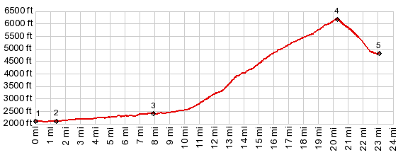
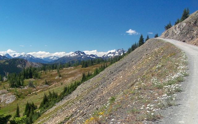
viewpoint, where it is cool even in July. After branching away from the valley road, Hart's
Pass road climbs in switchbacks up the steep tree
covered slope. During the climb the road passes
through a large fanking the valley, made of black,
volcanic rock. It is best viewed from above,
during the return, when the light towards the east
is much better. After a good workout the road emerges on a shelf
with sheer drop offs and two cone like peaks
across the valley. But soon after this the road
makes a right turn and runs up a shallow, hanging
side valley. The top always seems near, that
shallow forested gap just ahead, and it never is.
The road just keeps on climbing, and soon, looking
around, across the valley a ridge topped with
teeth like a saw comes into sight, and - yes it is
named the Sawtooth Range. The regular sticks
parade of burned forest completes the picture. More and more peaks surround this ridge the road
is traversing. The top of the pass is a busy
place: a campground, a small ranger station, a
trailhead parking lot and a small campground all
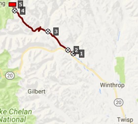
crowd around a well defined, narrow pass. Two roads branch off the pass road very close to
the summit, a road to a trailhead on the Pacific
Coast Trail, and the main attraction: the road to
Slate Peak.
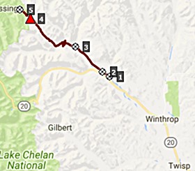
Out and back Sidetrip to Slate Peak: The
far views move up a whole degree of beauty on
these last 1500ft of climbing. The top is not
immediately visible, just a few switchbacks facing
south. As Mt Baker and other far peaks come into
sigh, the road traverses around the west side of
the ridge. This Lookout, even though
architecturally they are all very similar, is one
of the more picturesque ones, just because of the
well defined pedestal it sits on. And the views
from here ... I won't comment and leave it to the
side show.
 Dayride with this point as highest
summit: Dayride with this point as highest
summit:PARTIALLY PAVED / UNPAVED ( < FR43 Blackpine Lake s(u) | Washington Pass > ) Hart's Pass x2 : <> ~3.5miles of out and back with turn around point: "oh I forgot something" << <> a short distance up Goat Creek Rd <> down Goat Creek Rd > Manzama <> Lost River Rd west > up Hart's Pass Rd <> Hart's Pass <> Slate Peak << <> separate out and back from Harts Pass <> down west side of Hart's Pass with turnaround point at 5500ft << : 54.4miles with 66540ft of climbing in 6:40hrs (garmin etrex30 m5:17.7.27). Notes: nice temperature starting at 5500ft and above. On top of Slate Peak a great conversation with a wonderful Manzama photgrapher and her friend, who moved here from Wuerzburg at about the same age as me. You meet the nicest people on Lookouts and mountain passes.
|


 From West. (described
downwards). This side is much rougher but no
problem for a mountain bike. The road descends
steeply right away and there are no more far
views. The road eventually ends either after 4 or
9 miles. Sofar I have not gotten to the end of the
road, as there was too much to do on Slate Peak,
which seemed much more interesting.
From West. (described
downwards). This side is much rougher but no
problem for a mountain bike. The road descends
steeply right away and there are no more far
views. The road eventually ends either after 4 or
9 miles. Sofar I have not gotten to the end of the
road, as there was too much to do on Slate Peak,
which seemed much more interesting.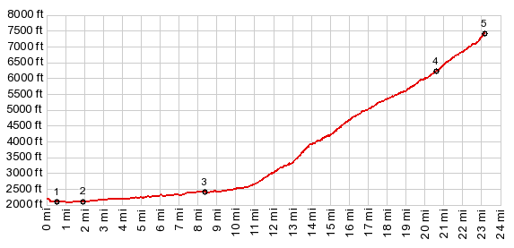


|
|
advertisement |
|
|
advertisement |