| |
| |
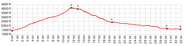
FR43 Blackpine Lake s(u)
The North Cascades in Washington
State have one paved road corridor. Unpaved road
go out from it dead end somewhere in the forest.
The cyclists that I met in this area, all pretty
much did the same thing : the "Northern Tier
route" publicized by Adventure Cycling. But just south of the North Cascades
there are several unpaved forest roads that can be
made into climbing loops with interesting summits.
This is one of the less steep ones. The rocky
peaks remain in the distance, but at least one can
admire them from afar.
At the top there is a small turnout and a view
down grass covered hills, dissolving into haze
before any details about the landscape can be
recognized. A few ft below the summit another
access road to Blackpine Lake joins from the
right, the Poorman Creek Rd. The very first interesting view
comes just after this intersection. It is
Blackpine Lake with its campground and the peaks
of the Sawtooth Range in the distance. All
pictures on the page were taken at this
campground. The amazingly clear light to the peak
above is even more impressive when compared with
the equally strong haze, when looking down into
the valley.
From North. (described
downwards) It is a fast roll down a good dirt
road, with little wear on the breakpads. Only
during the first couple of curves can slivers of
the peaks above be seen as background. Four miles
before meeting up with the Twisp River Road, the
road acquires a sort of pavement. The rough spots
may be difficult to recognize in time, when just
letting the bike roll. 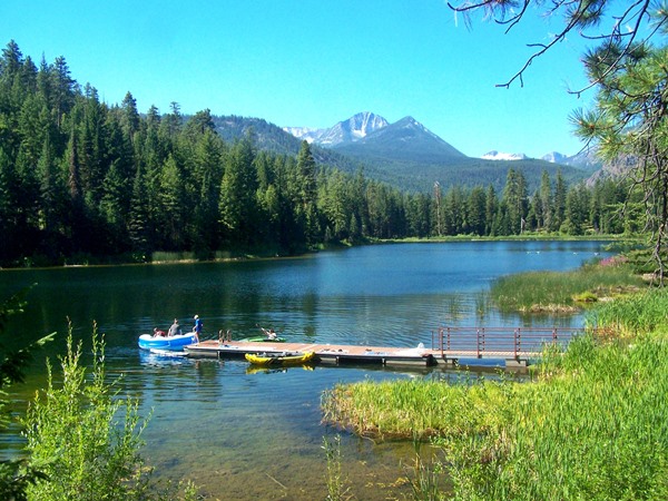
The profile also includes the following, shallow
descend along the Twisp River road back to Twisp,
a nice peaceful country ride with little traffic.
Abundant vacation houses take advantage of deep
shade next to the river.
Just a very short distance after passing the
Blackpine Lake, a singed turnoff goes up a oneway
climb to Buttermilk Butte. This road is
considerably rougher but has a very mountainbike
friendly surface, and hardly any "too steep"
grades. As I have become accustomed to from the
roads in the area, there is really not much to see
other than trees, until you get to the summit (not
counting one opening near the bottom). You can
even take the appearance of the first far views as
sign that the summit must be within a hundred feet
of climbing. Two short tracks lead to vantage
points onto peaks in the Sawtooth Range. During my
visit I had this entire vast landscape to myself.
 Dayride with this point as highest summit: PARTIALLY PAVED / UNPAVED ( < FR8220
Cooper Mtn Rd s(u) | Hart's Pass
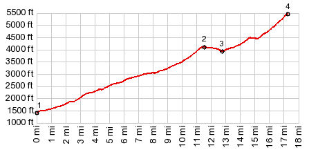
> ) SLIDESHOW of sidetrip to Buttermilk Butte
|
|
|
advertisement |
|
|
advertisement |