| |
| |
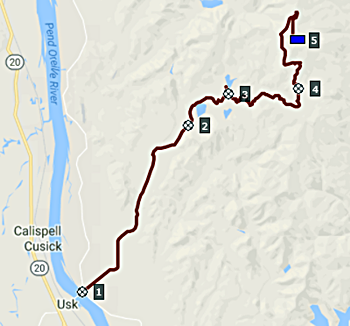
FR5080 King's Lake Rd -
Halfmoon Lake Rd s(u)
This ride goes mostly through forest
logging devastation, with a few token groves left
standing, just to show that not all is lost yet.
The scenically interesting part is the very last
section of the out and back trip to the forest
lookout.
By the time the road reaches the jct with
Halfmoon Lake Rd, it has become gravel with a
touch of washboard. From here a long curvy dusty
climb leads past King's Lake, featuring a private
campground on a public lake. The climb continues
to an unnamed saddle. Here there is the first hint
of a view down the valley - nothing but haze and
semblance of hills made into paper cutouts with
soft outlines. The road stays left here and
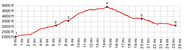
continues to go uphill. Always taking the uphill option will lead to the
Lookout. Coming back down the first right is the
way towards the two way summit on the profile.
This dirt road has less gravel and more logging
devastation and debris on the road than seen
sofar. There are plenty of views here and they are
all of partly clear cut hills, with little or no
care taken to restore the landscape. The road
reaches its highest point amongst this debris
 Dayride with this point as highest summit: ( < Banner
Ridge Rd s(u) | Sherman Pass
> )
|
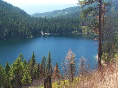 From South-2. (described
downhill) At the place where the road passes two
lakes along this descend, most of the forest has
been allowed to remain. The upper elevations have
been much more heavily clearcut. This approach
joins back to the South-1 approach. But there is a
way to descend all the way to the Pend-Oreille
without joining the other approach by taking a
right, at the first jct after passing the access
road to the upper lake
From South-2. (described
downhill) At the place where the road passes two
lakes along this descend, most of the forest has
been allowed to remain. The upper elevations have
been much more heavily clearcut. This approach
joins back to the South-1 approach. But there is a
way to descend all the way to the Pend-Oreille
without joining the other approach by taking a
right, at the first jct after passing the access
road to the upper lake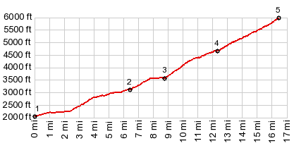
|
|
advertisement |
|
|
advertisement |