| |
|
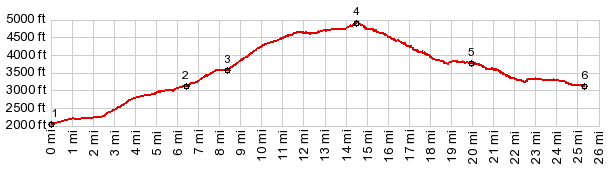
1.(00.0m,2040ft)START-END WEST-1: Skookum Creek Rd leaves the Pend Oreille River
2.(06.4m,3090ft)jct with King's lake Rd on left
3.(08.4m,3570ft)North Skookum Lake campground
4.(14.5m,4920ft)TOP
5.(20.0m,3780ft)road passes above Brown's Lake
6.(25.3m,2040ft)START-END WEST-2: same as point 2
|
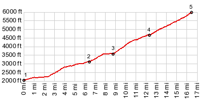
1.(00.0m,2040ft)START SOUTH: Skookum Creek Rd leaves the Pend Oreille River
2.(06.4m,3090ft)jct with King's lake Rd on left
3.(08.4m,3570ft)North Skookum Lake campground
4.(12.3m,4610ft)route diverts to right from the two way summit route
5.(16.5m,5970ft)TOP
|