| |
| |
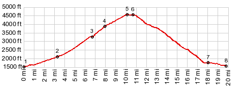
Banner Ridge Rd s(u)
The Clearwater Mountains south of
Grangeville have a large number of steep, smoothly
surfaced dirt road climbs. Like many other summit
points in this area, this point can be approached
many different ways, and the pictures and
description are for the particular approach I
tried out.
On top of the ridge the visitor is not only
greeted by a view of the Salmon Canyon, but also a
decision about which way to proceed at a T
junction. This is Banner Ridge Rd and the profile
goes right uphill. Surprisingly this is anything
but a wilderness up here. The road goes past a
large well endowed home, following the edge of
this slanted plateau shelf uphill. There is a
continuous great view towards the north. The
summit appears immediately after the road turns
away from the edge, in the forest, without views
From North. (described
downwards) There is another shelf with an incised
canyon waiting on this side, another T junction
too. Going right leads to higher points on another
good dirt road and eventually to Id14. The profile
turns left and takes a fast descent, mostly
between farms and hay bails, with widely variable
grades, in order to swoop down onto the village
White Bird like a falling bomb. The last part is
paved. - Great views of the switchbacks on Old White
Bird Grade.
A Dayride with this point as highest summit: PARTIALLY PAVED / UNPAVED ( < FR2028
Skookumchuck Rd(sh) | FR5080
King's Lake Rd - Halfmoon Lake Rd s(u) >
)
|
|
|
advertisement |
|
|
advertisement |