| |
| |
Cayuse Pass
Cayuse Pass is the third in
the list of scenic Mount Rainier two -way
summits. It is lower than Chinook Pass
and Paradise
s(u). It also has more traffic and fewer
reasons to stop. But there is one possible
vista point, that is arguably one of the most
attractive point onto Mount Rainier, at least
when the clouds play along. Cayuse Pass is
also a possible way point to the highest
one-way summit in the park: Sunrise.
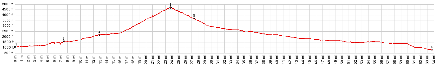
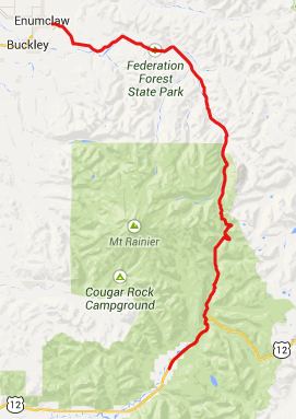
From South. From Packwood
US12 climbs intermittently. This is a busy,
noisy highway with a huge shoulder. A sign
stating "Mount Rainier National Park: 3miles"
appears at the junction with Wa123, hinting at
relief from all that noise. Most of the traffic
does stay behind, so does the shoulder. The road
climbs gently, without any turns to speak of,
for the first 2000ft. Bridges over wild
overgrown streams give a chance to get off the
bike and marvel at all that thicket, that seems
so impenetrable. There are one ot two views of the
Pinnacle area with a sliver of Mount Rainier
glacier in the background. But these are easy to
miss, and car travelers probably never even see
them. Approaching the top, the road is bound by
one of those picturesque stonewalls, and from
here is the closest thing to a Mount Rainier
view on this side. The pass is located at the
junction with Wa410, climbing higher to the west
over Chinook
Pass. There is no pass sign at this
location. Many maps do not label it either. But
one of the signs , located lower uses this name. From North. (described
downwards). There is quite a bit more traffic on
this approach, and only a very limited shoulder.
The road continues on its straight north - south
course. For me the outstanding moment on this pass ride came during late morning light. A sign warned of a congested area. The sign was right. It was a traffic jam on the hillside. Tourists stood, facing east, their socalled smartphones held high in front of them, like a catholic holds a sugar waver, pretending it's a piece of God. In the blinding light they were trying to make out the image on their glare obscured LED screens. It was an image of Mount Rainier, about as good as it gets. Prevailing south west winds had placed a translucent layer of clouds on top of the mountain, to arrange for a shifting display of light conditions. One second was better than the next. Meanwhile Japanese tourists left the motors on their rented luxury mobiles running, and posed their wives and babies in a professional looking manner in front of the volcano. My jaw dropped at the spectacle of the mountain, and the spectacle of its spectators. This potentially awe inspiring
view onto Mount Rainier really has 3 possible
spots to stop at on a bicycle. Possibly the
nicest is one over a bridge. The "congested
area" is the last possibility.
Sidetrip to Sunrise: I was told that this was the
highest paved road in Washington. But first it
descends to cross Shaw Creek, and also pass the
National Park entrance station. Even though
Cayuse Pass in inside the national park since
three miles after the start of Wa123, there is
no entrance fee, until now. During my visit on
Memorial Day, the queue of cars was at least 2
miles long. But traffic on the Sunrise Park road
was mercifully light, and oh so considerate.
After waiting so long to get in, I guess they
were in no rush to get out. The first several miles of this
road are just your ordinary ride through the
forest. Then the mountain appears above, the
glacier as flat as a curtain on a window, but
9000ft high. The best part are the miles before
and after Surnise Point. The road crests just
before reaching the Sunrise visitor center, and
this section shows off the mountain the best.
But nobody seems to stop here, probably because
they don't want to stop before reaching the
predefined destination - a big parking lot with
a snack bar, and in my case a helicopter and
several ambulances working on a mountain rescue.
On photos this road often looks a lot higher
than it actually is, thanks to the spectacular
backdrop, which actually reaches over 9000ft
above the road.
Dayride ( < Paradise s(u)
| White Pass
> ) - |
 Approaches
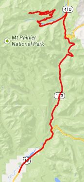 Comparatively
speaking, after that it's an eventless roll to
the bottom. There is the possibilty to turn the
excitometer back up to full throttle, by taking
a left turn onto the out-and-back road to
Sunrise.
Comparatively
speaking, after that it's an eventless roll to
the bottom. There is the possibilty to turn the
excitometer back up to full throttle, by taking
a left turn onto the out-and-back road to
Sunrise.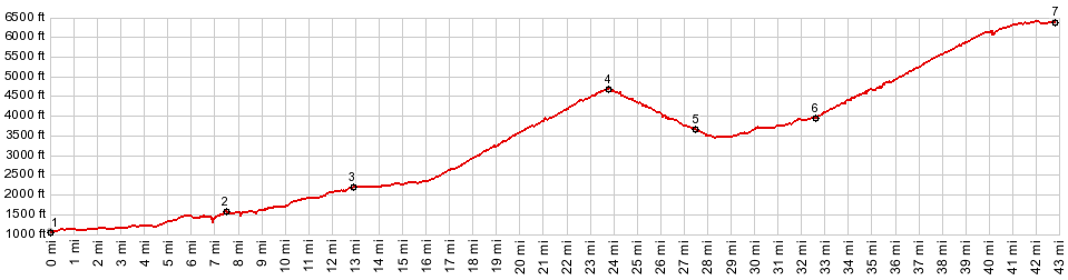
|
|
advertisement |
|
|
advertisement |