| |
| |
Ut9 Zion National Park s(u)
This is the Mount Carmel Road
through Zion National Park. But the summit point
is a couple of miles west of the Park. On the east
side bicycling is illegal through the longer one
of two tunnels. The only other cyclists I saw on
the road east of the tunnel, were all Europeans
going around the world, Signs along the road never
even address the topic of bicycling through the
park. Once at the tunnel, most through going
cyclists just try to hitch a ride with a truck
through the tunnel. Long lines of stopped cars
develop when the tunnel is used in one direction
only, by a high profile vehicle. This is a common
occurrence.
The highest point, comes as mentioned, a couple
of miles before entering the park. There is no
sign, no interesting view, just a business of some
sort, and a turnoff up (another road named) North
Creek Road. This North Creek Road is paved to
within a couple of miles of the Observation Point
Trailhead, leading into a more remote area of Zion
National Park. 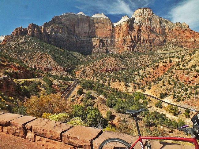 From East. (also
described upwards). The entire road between I15,
Anderson Junction and Zion NP has a wide shoulder,
most of the time with more than enough space for
cycling even side by side - sometimes even a
marked bike lane. Some of the pavement on the
lower sections is a little rough for more
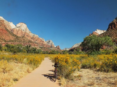
sensitive tires. Riding through the Hurricane Cliffs area is a
nice introduction to this fantastic landscape. On
the left is the climb to Hurricane
Mesa. Rockville still has enough peace and
quiet to let you appreciate the Mormon sized
streets. The next town, Springdale, is something
approaching the typical National Park edge town.
But I didn't see any go cart tracks or min golf
courses, as I hurried through.
On the east side of the tunnel another guard
keeps watch, that things are happening in a
orderly manner. When asked how to proceed through
the tunnel, as a cyclist in the opposite
direction, the official advice given is to
hitchhike. In my case the line of cars, waiting to
enter the tunnel was 1.3miles long, on a Monday in
October shortly before noon. The road is fairly narrow. But that is great.
With all these turns and everybody here in order
to be here, it was a great ride with lots of
space. Of course it was very busy.
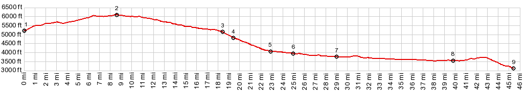
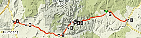
Dayride with this point as the highest summit: PARTIALLY PAVED / UNPAVED / TRAIL ( < Ut261 via Snowflats Rd(sh) | Hancock Rd s(u) > ) Ut9 Zion National Park s(u) x2 , jct US89 - Ut43 Pink Corral Sand Dunes State Park(sh) , separate out and back: about 1.5 miles south of jct US89 - Ut43 <> Ut43 north <> Mount Carmel Jct <> Ut9 west <<>> on way back only separate out and back <> North Fork Rd north <> Twin Butte(?) Rd east <> turnaround point just beyond highest point on Observation Point Trail >> Ut9 east in Zion NP << turnaround point this side of Carmel tunnel >> back to starting point: 70.7miles with 5150ft of climbing in 6:34hrs (garmin etrex30 m3:19.10.7) Notes: the trail to "Observation Point" is easily bikable (at least the initial 2.5 miles to the high point) It is not signed as being illegal to bicycle. I didn't notice that it was inside Zion NP until after return. It was then that I noticed the small Zion sign at the trailhead. "Observation Point" is not the initial high point on the trail, but instead a lower point that comes several miles later. But there are some great views in the initial section too. The trail here is a wide trail often 100ft from the rim, where some usage tracks suggest a possible great view from a detour through the bushes .. and there are a few monumental views if you look for them. The ride to the west side of Mt Carmel tunnel was a separate daytrip, starting about 1mile west of jct Mesa Rd - Ut9, and also including a ride to the end of Mt Zion Dr (58.4miles with 2370ft of climbing in 4:48hrs (garmin etrex30 r4:19.10.16). |
 Traffic
going up towards the tunnel is heavy, but slow and
considerate. A handful of switchbacks climb up to
the gum line of the surrounding giant rock teeth.
In my case the October light was constantly
incredible. Approaching the tunnel, a guard keeps
watch on any irregularities, such as a cyclist
without a car ride, heading for the tunnel.
Traffic
going up towards the tunnel is heavy, but slow and
considerate. A handful of switchbacks climb up to
the gum line of the surrounding giant rock teeth.
In my case the October light was constantly
incredible. Approaching the tunnel, a guard keeps
watch on any irregularities, such as a cyclist
without a car ride, heading for the tunnel.|
|
advertisement |
|
|
advertisement |