| |
| |
Ut261 Cedar Mesa via
Snowflats Rd(sh)
Start with the Good: amazing
soutwestern canyon and mesa scenery, adventurous
roads, no people. The Bad: sand, sand, sand. So
much sand I couldn't decide weather to write up
this page. But then the sand is limited to the
middle part of Snowflats Rd. Going down it may be
easier than going up it, as the description does.
Also - this may be a great argument for a fat tire
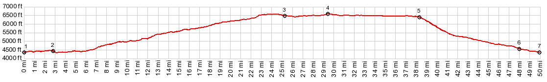
bike. My tires were less than medium obese. Glancing at the profile below, it
looks like a different point before point 3 would
be the summit. But according to the contour lines
point 3 really is the true summit by a minute
amount.
As the road approaches a forested plain on top,
sand becomes more and more common. There comes a
point when it becomes clear, that if the sand
continues at this pace, there is no way of
reaching the paved road by darkness. You just
can't walk that fast. The worst of the sandy areas
starts at a popular parking lot for a wilderness
study area with archeological value. But then eventually the sand does end, and
progress to the Ut261 becomes very fast. Time to
clean out those shoes and make them a pound
lighter each. Without a trace on a map it is impossible to
determine the real summit. As it turns out the
straight, fast road over the forested top has a
point that is 20ft higher than the highest point
on Snowflats Rd
From South. (described
downwards) There is another major attraction on
this loop, and it comes as a complete surprise to
the uninitiated first time visitor. In the middle
of the forest signs warn to slow down to 15mph,
without a turn in sight. What could this possibly
be ? The road arrives at the edge of Cedar Mesa,
turns to gravel and descends along a sheer
vertical drop for over 4 miles. The rest of the
description are the pictures.
Slideshow of Snowflats Rd approach
Dayride with this point as highest summit: PARTIALLY PAVED / UNPAVED ( < North Creek Rd - Hart's Draw Rd s(u) | Ut9 Zion NP s(u) > ) Ut261 Cedar Mesa via Snowflats Rd(sh) , US163 Mexican Hat - Bluff s(u) : jct CR237 Snowflats Rd - CR235 Comb Ridge Rd > up CR237 Snowflats Rd > Ut261 south > Ut261 Cedar Mesa via Snowflats Rd(sh) > Ut261 south > US163 east > US163 Mexican Hat - Bluff s(u) > back up CR237 Snowflats Rd to starting point: 62.0miles with 4090ft of climbing in 6:40hrs (garmin etrex30 m3:19.10.3). Notes: On the southern descent I met Santa Fe artist Krista Elrick. While her husband was up on the viewpoint taking in the dramatic scenery, we had a great talk about various happenings, centered around Texas license plates, the era of orange hair males, and life in general. Pictures were taken. Thanks for the peach and the brownie. They helped me get back much faster. Also nice late light views from the surprising summit on US163 going back towards Bluff Slideshow of Ut261 Cedar Mesa approach
|
|
|
advertisement |
|
|
advertisement |