| |
| |
Ut56 Cedar City - New Castle Summit Paved Ut56 is a fast and
furious highway without shoulders, close
to Cedar City. Maybe at times it's not
quite that bad, but a perfect cycling
route looks different. Enter this
alternate approach on good gravel roads.
It is even part of an official "gravel -
trail[road]" net. I discovered this when I
saw a small sign along the road with a
bicycle on it. This gravel road system is
made for commercial mining trucks, and
every once in a while you meet one. But,
judging from their behavior, something or
someone must have convinced them to be as
considerate as humanly possible and slow
down to minimum speed when encountering
another vehicle such as a bike. You can
see them coming from miles away by a vane
of blowing dust, but once they are face to
face - I have never met any more
considerate automobile drivers.
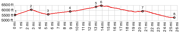
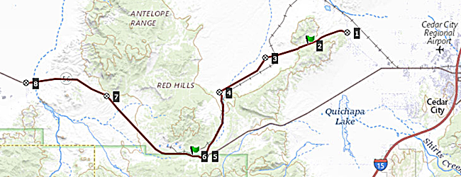 Approaches The profile starts in ash
colored cedar hills, not far from a
collection of strange buildings and an rv
park, calling itself a resort, and labeled
Iron Springs on the map - to be more
precise, the profile starts at the
intersection of Iron Springs Rd and Desert
Mound Rd. The profile starts out on the
latter and first crosses something called
Eightmile Pass on maps, without the hint of
a turn. Cresting this summit is nontheless
memorable because of the stark view on the
other side. A wide valley is cut into
triangles by two straight lines - both
roads. You meet the junction of these two
lines on the other side of Eightmile Pass.
The left (more southerly) option is the
subject of this page and it leads to the
UT56 summit, while the right one (more
northerly option) goes over a slightly lower
unmarked/ innamed summit keeping the name Desert
Mound Rd. This southerly option splits
again in two. The first option is staying
left immediately after the railroad
crossing. It is a little shorter. It is also
the route on the profile, but also contains
a short very rough and rocky section, before
the two options meet. The second option is
staying on Dessert Mound Rd to a major
intersection, and then going left there.
Even though there are no road or directional
signs at these crossings, there is a small,
easily misinterpreted "Color County Gravel
Trail System" sign (featuring a bicycle) and
an arrow in the direction of the described
route. After the two routes meet up
again, the road seems to head straight for
the ore processing facility of Iron
Mountain, but then cuts left before the
plant entrance, following close to the rail
line. The last part is a wide paved road. It
connects with Ut56 shortly before the
summit, and there is even a ridable shoulder
on the right side of the rumble strips,
lasting a short distance past the flat
featureless summit. 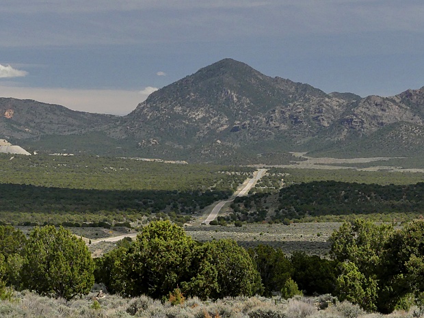
From
West. (described downwards). Pinto Rd
takes off near the general summit area and
climbs a little higher. After the
summit Ut56 road contours around a hill
named "Iron Mountain". All that is left of
this land feature is a series of mined
terraces, looking out over the landscape
like condo-balconies, crowded together in an
Italian Riviera resort. But to get an
impression of this you have to gain some
distance, like going down Old Ironton Rd. On this side the profile
follows Ut56 itself the entire distance, and
traffic is no longer an issue worth loosing
words on. The road soon looses the shoulder,
but who cares?. A long flat dessert ray
heads for the junction with Desert Mound Rd,
and a further shallow decent leads into the
collection of trailers, houses and cars,
collectively known as New Castle. 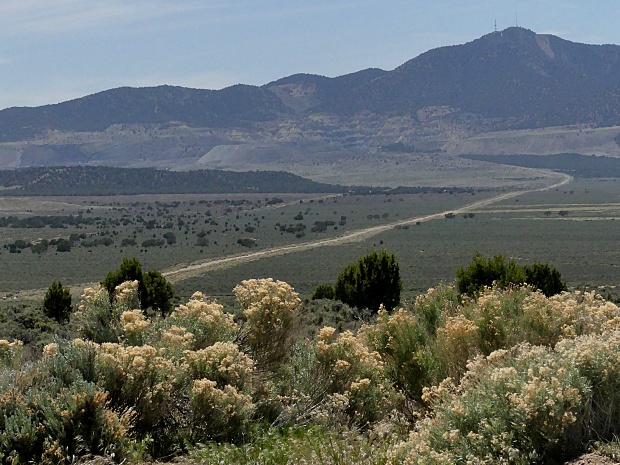
Dayride with this point
as highest summit: PARTIALLY PAVED / UNPAVED ( < Pinto Crest s(u) | Arrowhead Pass > ) Ut56 Cedar City - New Castle Summit , Dessert Mound Rd s(u) , Eightmile Pass x2 , additioinal out and back: Old Ironton Rd, a few miles from jct with Ut56 <> out and back to Old Ironton and south on Old Pinto Creek Rd till turnaround due to deteriorating road >> Old Ironton Rd north > Ut56 west > Dessert Mound Rd east > Dessert Mound Rd s(u) <> out and back on Iron Springs Rd south to jct with Ut45 <> separate out and back on Iron Springs Rd north to Iron Springs >> back over Eightmile Pass on Dessert Mound Rd > unmarked rd west, heading for Iron Mountain > Comstock Rd south > Ut56 west > back to starting point on old Ironton Rd: 56.0miles with 3550ft of climbing in 5:32hrs (garmin etrex30 m3:22.5.9) Notes: strong headwind on way back |
|
|
advertisement |
|
|
advertisement |