| |
| |
Arrowhead Pass This is a low gap in the Indian Peak Range, separating Hamblin Valley from the Escalante Dessert. It is remote dessert country with few people, high sage valleys and endless views. The profile below represents
an entire loop over the summit, made up
completely of gravel roads. I chose the
lowest point on the profile as a starting
point. But there are more convenient
starting points along the profile.
The road to Arrowhead Pass
first has to cross a sandy wash in the wide
expanse of this valley first. Still the road
is completely rideable. Even as it climbs
into the cedar forest the road remains
straight as an arrow, with a few breaks in
the trees. At the top is a short steep
section and several turns. 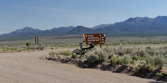
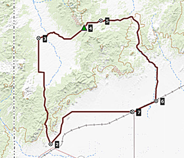
From
East. (described downwards). The road
changes direction at the summit. So now the
motto is "down and southwards". Progress to
complete a circuit now seems to fly by fast.
Half an hour past the summit the Indian Head
Range is already a figure at the horizon,
resembling an egg container in form, but
much more beautiful. A right turn along the
mountains leads onto Pine Valley Road. It
appears to be kept in excellent condition.
Its entirety traversing the valley end to
end, it is just too long to be useful, if it
were not maintained as a fairly smooth
surface. On this loop it keeps decending at
a shallow but constant rate, all the way to
the railroad frontage road. This road has
all the appearances of a main road in the
deLorme atlas. But it is just a straight
gravel road, following the UP railroad
through the Escalante dessert.
Dayride with this point
as highest summit: COMPLETELY UNPAVED ( < Ut56 New Castle Summit | Confidence Mine s(u) > ) Arrowhead Pass : partly up Modena Canyon Rd > Modena Canyon Rd north > Hamlin Valley Rd north > Arrowhead Pass Rd east > Arrowhead Pass > Pine Valley Rd south > Railroad Frontage Rd south west > Beryl > 10400N Rd west > Eight Mile Rd west > Modena Canyon Rd north back to starting point: 82.6miles with 3910ft of climbing in7:35hrs (garmin etrex30 m3:22.5.12). |

|
|
advertisement |
|
|
advertisement |