| |
| |
FR009 Pinto Crest s(u) This is a good dirt road to
a small community, surrounded by low
mountains. These are covered with a
extensive pinyon juniper forest, which
comes as a surprise for this dessert area.
There is some traffic on this road. But it
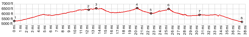
is not a washboard surface. There are 3
separate high points along the way. They
are separated by more than 300 but less
than 500ft of climbing. I can see no other
sideroads that would permit a 500ft
approach height to approach these points
separately. So I am only counting this as
one summit. The highest one seems to be
the first one, by a minute amount. The map
accuracy is barely enough to come to that
conclusion. It is all just a matter of
feet. While on the road, the southern most
high point feels the highest with the best
views.
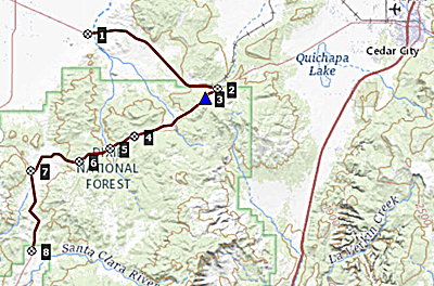
During the final decent to
Grass Valley Rd, the crest of the Pine
Valley Mountains appears as a surprising
sharp ridge in the background of a sea of
wave like rounded hills. While my dayride
below turns right here to return over a
summit on Ut18, the profile below turns
left, to Enterprise, direction Escalante
dessert, in order to maximize the elevation
gain.
Dayride with this point
as highest summit PARTIALLY PAVED / UNPAVED ( < Ut`130 Cedar City - Minersville Summit | Ut56 Cedar City - New Castle Summit > ) FR009 Pinto Crest s(u) , Ut18 Central - Pine Valley s(u) : Old Ironton Road, a few miles from junction with Ut56 < Old Ironton Rd north > Ut56 east > FR009 Pinto Road south > FR009 Pinto Crest s(u) > FR009 south > Ut18 north > Ut28 Central - Pine Valley s(u) > Enterprise with sightseeing detour > Bench Rd north with two small detours, including an out and back on Ut18 > New Castle > Ut56 east > back to starting point on Old Ironton Rd:57.4miles with 3700ft of climbing in 5.11hrs (garmin etrex30 m3:22.5.7). |
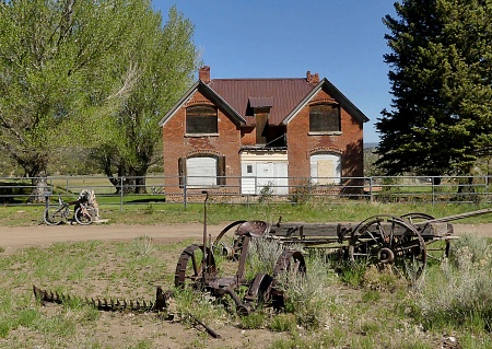 From South. (described
downwards) On the next decent, the road
passes an old historic home from the iron
mining period in this area, and then climbs
to the first intermediate high point. All of
the three highpoints have nice views of the
road stringing through the hills.The town
Pinto is after the second high point,
probably just a few feet lower. The town
Pinto is a major collection of dirt road
crossings, signifying its importance in
history. Today it is a collection of
vacation homes and a parking lot of large
travel trailers.
From South. (described
downwards) On the next decent, the road
passes an old historic home from the iron
mining period in this area, and then climbs
to the first intermediate high point. All of
the three highpoints have nice views of the
road stringing through the hills.The town
Pinto is after the second high point,
probably just a few feet lower. The town
Pinto is a major collection of dirt road
crossings, signifying its importance in
history. Today it is a collection of
vacation homes and a parking lot of large
travel trailers. |
|
advertisement |
|
|
advertisement |