Desert Mound Rd s(u)
 The
summit on Desert Mound Rd is a gravel
biker's alternative to the Ut56
Summit Cedar City -New Castle. The
route is part of an official "gravel
trail" system. This summit is just
slightly lower than the Ut56 summit, but
the traversal of "neck of the dessert", as
the valley on the east side is called on
maps, is much more satisfying for a
healthy hunger after dessert scenery. The
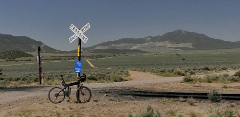
road surface is excellent, because the
roads are also used by commercial mining
trucks. Sounds scary, but it is not. There
are very few and in my experience they
were all extremely considerate ... unless
one has a fear of dust vanes from a
distance. There are plenty of those. The
summit on Desert Mound Rd is a gravel
biker's alternative to the Ut56
Summit Cedar City -New Castle. The
route is part of an official "gravel
trail" system. This summit is just
slightly lower than the Ut56 summit, but
the traversal of "neck of the dessert", as
the valley on the east side is called on
maps, is much more satisfying for a
healthy hunger after dessert scenery. The
road surface is excellent, because the
roads are also used by commercial mining
trucks. Sounds scary, but it is not. There
are very few and in my experience they
were all extremely considerate ... unless
one has a fear of dust vanes from a
distance. There are plenty of those.
 |
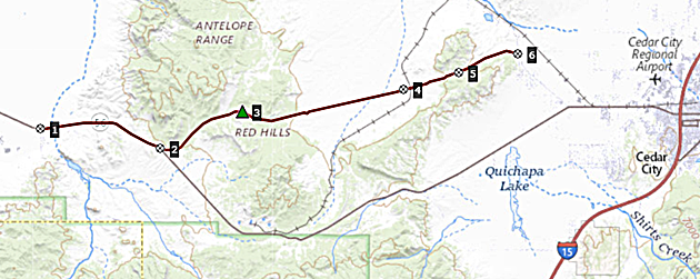
1.START-END WEST: jct
Ut56 - Main St, Newcastle
2.profile turns left onto Dessert
Mound Rd
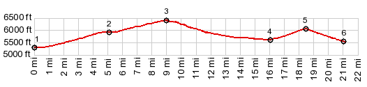
3.TOP:6400ft
4.low point on road, just before
railroad crossing, 5600ft
5.Eight Mile Pass: 6040ft
6.profile turns right on Iron
Springs Rd
7.START-END EAST: jct Iron Springs
SRd - Ut56
|
Approaches
From West. The
profile starts out on quiet dessert pavement
in the collection of trailers, houses and
cars labeled "New Castle". By the time this
gentle climb meets the labeled turnoff onto
Desert Mound Rd, a good part of the climbing
is already past.
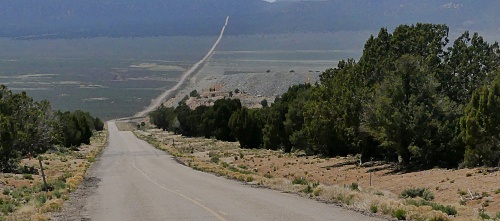
What remains is a straight run
through the cedar forest on good hard gravel
surface till the view shed changes.
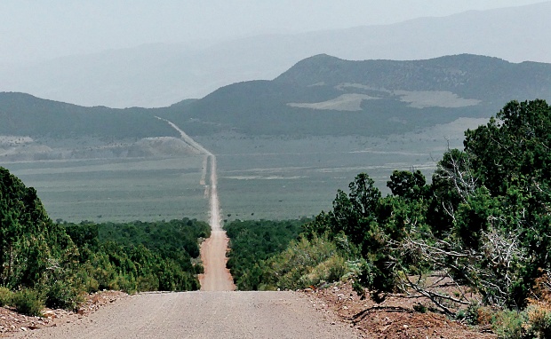
 From
East. And this side is actually far
more impressive in my mind. But there is a
thin difference between spectacular vastness
and monotony. Downhill it's very
mesmerizing. Uphill against the prevailing
winds I imagine could be different. This
road is as closest to a straight line, one
can imagine. There is one slight change in
direction, so that the line can negotiate
another summit. It is labeled Eightmile Pass
on my map, and it is included in the
profile. On this side the climb to Eightmile
Pass is just a little above 300ft (100m).
The other side is larger than 500ft, and you
could connect to that via a valley route
from the west also. Therefor I am counting
it as a separate summit. From
East. And this side is actually far
more impressive in my mind. But there is a
thin difference between spectacular vastness
and monotony. Downhill it's very
mesmerizing. Uphill against the prevailing
winds I imagine could be different. This
road is as closest to a straight line, one
can imagine. There is one slight change in
direction, so that the line can negotiate
another summit. It is labeled Eightmile Pass
on my map, and it is included in the
profile. On this side the climb to Eightmile
Pass is just a little above 300ft (100m).
The other side is larger than 500ft, and you
could connect to that via a valley route
from the west also. Therefor I am counting
it as a separate summit.
|