| |
| |
Parley's Summit
I80 is never going to be the first choice to cross the Wasatch Range on a bicycle. But with so many other options available, Parley's Summit is always a possibility to return quickly to the starting point on the other side of the mountains. This is not a quiet or great smelling ride. But it is safer than many small country roads, that in reality are overloaded expressways without a shoulder.
Approaches
The initial part of I80 leads along exits leading to blocked off roads or quarries. It's a long gradual grunt through desert hills that have been rechristened into "mountain dells" by real estate developers. No alpine peaks or incised canyons are visible on this route. The closest thing to a scenic experience is the exit leading to the low point between Little Mountain Pass and Big Mountain Pass ( second picture ). The top has long been populated by suburban type homes, a gas station and strip malls, interspersed with the occasional mormon temple mega complex. There is also a mountain park and an elevation sign.
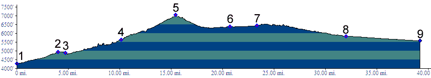
Dayrides (unpaved+paved): A loop ride beginning in Midway, leading over Guardsman Pass to Holladay City in the Salt Lake Valley, then returning over Parley's Summit measured 82 miles with 7740 feet of climbing in 7.1 hours, using a Cateye A100 cycle computer. (m3:6.6.4) (single track+unpaved+paved): A loop ride from Silver Crossing ( junction Ut248 - US40 ) to Park City, up to Guardsman Pass, over the the Wasatch Crest Trail summit(u) down Mill Creek Canyon, returning via I80 and Parley's summit measured 64 miles with apr. 6400ft of climbing in 7:1 hours, using a VDO MC1.0 cycle computer (m3:07.06.11).History The Overland Trail ( < North Ogden Pass | Daniel's Summit > ) In 1849 and 1850 Howard Stansbury mapped passes to the east of the Great Salt Lake, while looking for a better supply route between the Oregon Trail and Utah. During that time Parley's Summit was known as Golden Pass, named for the high toll road prices charged by Parley P Pratt, the mormon leader and owner of the toll road over the pass.By 1850 Stansbury had become convinced that there was better route east from Salt Lake, than a direct connection with the Oregon Trail to the north. This later became the Overland Route, and replaced part of the Oregon Trail. He started to explore this route with his guide Jim Bridger as he left Utah over Parlely's Summit. But he recommended Provo Canyon (leading to Silver Summit) as best route for this. After that the route continued over Strawberry Pass, today more commonly called Daniel's Summit. |
 From West. Following Avenue
3300 in Salt Lake City south to its western end
may be the most convenient way to get onto I80 to
Parley's Summit. Shortly before the freeway
entrance a large REI store as well as a host of
other shops provide a chance to stock up on brake
shoes, or whatever else has been broken or
depleted on the ride sofar ( in my case it was a
pair of cleats ). Unlike other bike stores in the
area it is also open on Sundays. When coming from
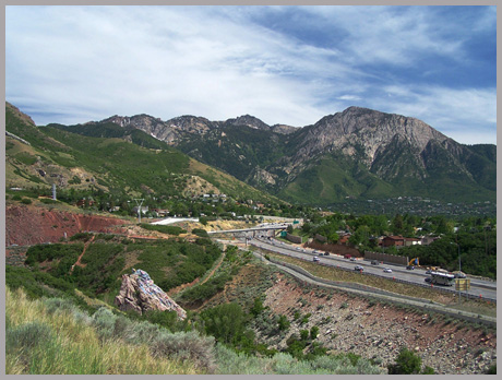
the mouth of Mill Creek Canyon, bicycle traffic is
funneled away from Parley's Canyon to Parley's
Crossing. This interesting bike path construction
does not exactly make it easy to get onto I80, but
it is possible. I took the first picture while
looking for the way.
From West. Following Avenue
3300 in Salt Lake City south to its western end
may be the most convenient way to get onto I80 to
Parley's Summit. Shortly before the freeway
entrance a large REI store as well as a host of
other shops provide a chance to stock up on brake
shoes, or whatever else has been broken or
depleted on the ride sofar ( in my case it was a
pair of cleats ). Unlike other bike stores in the
area it is also open on Sundays. When coming from
the mouth of Mill Creek Canyon, bicycle traffic is
funneled away from Parley's Canyon to Parley's
Crossing. This interesting bike path construction
does not exactly make it easy to get onto I80, but
it is possible. I took the first picture while
looking for the way.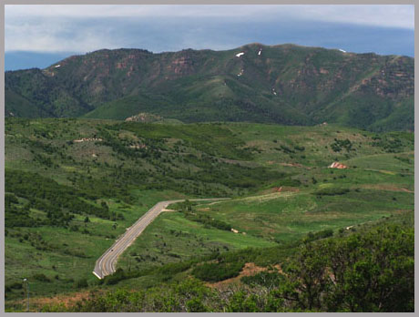 From East. (described
downwards). Signs warning of a downhill ahead make
the cyclist feel hopeful. But in reality it is
quite short and straight on this side. In the past
it lead past signs advertising full ownership in
leftover olympic housing complex units, turned
condo, for a mere 500 000 dollars. Sorry - all
sold out. A frontage road runs along the south
side. But it is safer to stay on the interstate,
since the busy business route has no shoulder.
Much of the suburban commuter traffic along the
route takes a right along another traffic monster
to Park City. Continuing along I80, the mountains
behind Park City look less dramatic from this
side, seen between a sea of developing suburbia.
With a strong west wind it's a fleeting impressing
that floats by quickly, almost as if seen from
behind the protecting wind shield of a speeding
car. More often the wind blows in the
other direction, and the ride can be less pleasant
at the end of the day in rushhour traffic.
From East. (described
downwards). Signs warning of a downhill ahead make
the cyclist feel hopeful. But in reality it is
quite short and straight on this side. In the past
it lead past signs advertising full ownership in
leftover olympic housing complex units, turned
condo, for a mere 500 000 dollars. Sorry - all
sold out. A frontage road runs along the south
side. But it is safer to stay on the interstate,
since the busy business route has no shoulder.
Much of the suburban commuter traffic along the
route takes a right along another traffic monster
to Park City. Continuing along I80, the mountains
behind Park City look less dramatic from this
side, seen between a sea of developing suburbia.
With a strong west wind it's a fleeting impressing
that floats by quickly, almost as if seen from
behind the protecting wind shield of a speeding
car. More often the wind blows in the
other direction, and the ride can be less pleasant
at the end of the day in rushhour traffic.|
|
advertisement |
|
|
advertisement |