| |
| |
Paiute Side Trail 005(sh) So why do I keep riding ATV trails
instead of designated bicycle trails ? I don't
know. But it must have something to do with the
way I pick destination summits. I pick them if
the topopraphy looks interesting on the map. And
since this is a nation of many more motor heads
than hammerheads, the route leading there is
more likely to be an ATV trail. So is this one. Like many other
trails/roads in this area there is no
interesting view from the gentle forested top.
The interesting topography comes at the edge of
the plateau, during the decent to Beaver.
Unfortunately that's also where all the rocks
and the torn up sections are.
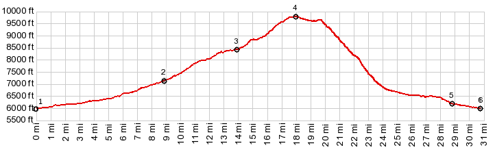
This side is very ridable. It leads
up a shallow ravine, that always has another
higher section show up, just as you reach the
apparent summit. There are no views from the top
of this flat forested plateau
From South-2.
A much smaller part of this side is ridable.
Ridable and unridable sections alternate almost in
a regular fashion. Short stretches are extremely
rocky and steep. At maybe half height an open view
direction Beaver opens up. This occurrence is rare
enough, that two picnic tables have been
transported up here, and tracks indicate this is a
major meeting point. The remaining way down also
opens up a few views back onto high peaks in the
Tushar Mountains. Nexit: a memorable, unexpected
sandy stretch, that can cause faceplants. I can
testify to this. Following the PST005 signs, leads
over an ever so gently descending alluvial fan
back to the Beaver Canyon main road.
Dayride with this point as
highest summit: PARTIALLY PAVED / UNPAVED ( < Beaver Canyon Rd s(u) | Clear Creek Summit > ) Paiute Side Trail 005 s(u) : a short distance up FR122 > down FR122 > up Beaver Canyon Rd > PST005 west > Paiute Side Trail 005 s(u) > down PST005 on west side > North Creek Rd south > ending near jct with Beaver Canyon Rd: 28.7miles with 3790ft of climbing in 5:30hrs (garmin etrex30 m3:22.6.1) Notes: At mileage 20.x I noticed that the rear skewer and the rear derailuer hanger screw were gone, as well as a rear deraileur hanging in the chain. This probably had its original cause from a crash several miles earlier in a sandy section. I covered the remaining distance with a mixture of coasting down the shallow alluvial fan and walking. In Beaver Creek Canyon I was saved by Ron and Deb in an ATV truck of sorts (at least that's what it looks like to me) who drove me back to the starting point. This is the second ride on this trip that i couldn't finish on my own. |
|
|
advertisement |
|
|
advertisement |