| |
| |
Clear Creek Summit I70's western most summit after
its start from I15 is named North Creek Summit.
On the east an older road paralleling the
Interstate, one drainage away, makes for a
perfect cycling route.
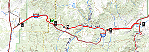
North Creek Canyon Rd soon crosses
I70 and then parallels it through Fremont Indian
State Park. There are many petroglyphs visible
from the road - if you have the eyesight of an
eagle. For people with average vision or below,
short trails lead to signs pointing them out. Soon
after the State Park Visitor center, I70 and North
Creek Canyon deviate into the adjacent ravine.
Clear Creek Canyon is narrower, green and pleasant
- no traffic. Climbing out of the valley the road
reaches a short section with excellent views onto
the Tushar Mountains. The summit is reached
immediately before joining I70. There is a sign
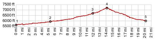
with elevation and name. So summit points on Clear
Creek Canyon and North Creek Canyon are separtes
points, but very close together.
This side of the profile follows I70
all the way. There is plenty of room on the right
side of the rumble strip on a super spacious
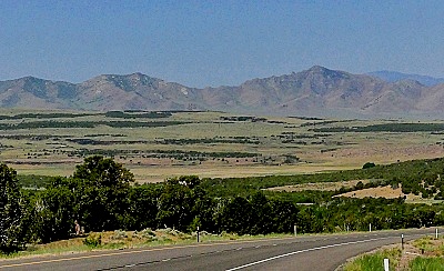
shoulder. Looking back, the country west of here
consisits of drier, lower mountains, a transition
between the Colorado Plateau and the
Basin-and-Range topography. 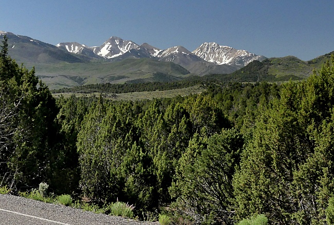 Dayride with this point as
highest summit:
COMPLETELY PAVED: ( < PST005 s(u) | > ) Clear Creek Summit x2: Partly up Clear Creek Canyon Rd > up Clear Creek Canyon Rd > Clear Creek Summit <> out and back down I 70 to exit 1 and turnaround point at Cove Fort >> down east side of I70 <> out and back from US89 exit on Marysvale Canyon bike path to turnaround point at Candy Mountain Trailhead >> west up Clear Creek Canyon Rd back to starting point: 58.7miles with 3570ft of climbing in 5:03hrs (garmin etrex30 m3:22.6.7) Notes: beginning of a heat wave. |
 From
West. (also described upwards) I70 reaches
a low point, just 1 mile after it starts from I15.
Here at milepoint 1 is exit 1. One mile north
leads to fort built during the 1870s for Blackfeet
Indian hostilities. Today, a friendly pair of
saintly hosts are there to elucidate its history,
and take on any and all questions about its
history. I was tempted to make a fairly long
conversation even longer, but it was going to be a
hot day.
From
West. (also described upwards) I70 reaches
a low point, just 1 mile after it starts from I15.
Here at milepoint 1 is exit 1. One mile north
leads to fort built during the 1870s for Blackfeet
Indian hostilities. Today, a friendly pair of
saintly hosts are there to elucidate its history,
and take on any and all questions about its
history. I was tempted to make a fairly long
conversation even longer, but it was going to be a
hot day.|
|
advertisement |
|
|
advertisement |