| |
| |
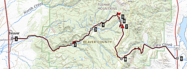
Beaver Canyon s(u) -1
Ut153 between Beaver and Junction is an enigma. At least part of the upper portion of the eastern approach from Junction is deep gravel - so deep, that is so difficult to ride in ... so deep, it makes you ask "why is this kind of biking so popular anyway " ? It is a kind of UDOT counterpart to their famously dangerous rumble strips on paved roads. On the other hand, the western
approach from Beaver is a paved road perfect for
cycling, with little to no traffic, great surface,
scenery that is not bad for super-high Utah
standards. And ... the only reason that is so - is
because of the bad surface on the other side,
which keeps traffic away. Beaver Canyon first reaches an
signed summit on pavement, and then continues to
this second unpaved highest point on the road
between Beaver and Junction. There are many other
gravel road turnoffs along the way to explore,
including an even higher gravel loop summit on
FR123.
 Approaches
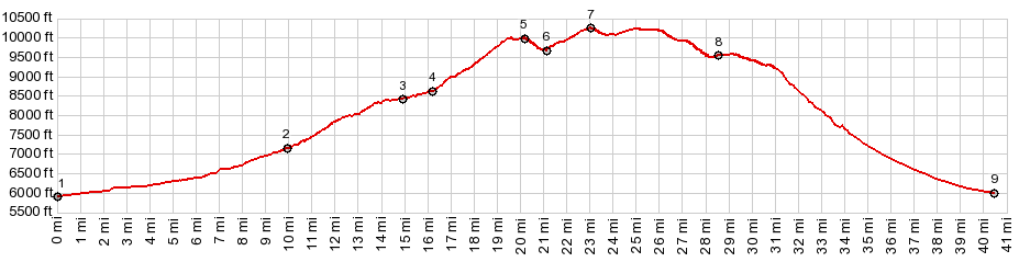
The decent before the profile starts
climbing again is less than 500ft. But if you take
a right, near the signed junction to Puffer Lake
on the other side, then the approach size on this
side becomes larger than the required 500ft. I am
calling that summit Beaver Canyon Summit-1 At the junction the pavement also
ends and the road promptly climbs to a higher
elevation surrounded by forest. However
approaching the rolling top section, the road
crosses miles of expansive alpine meadows with
alpine peaks showing up all around - by far the
most scenic section of the ride. From West. Unfortunately
the road becomes deep coarse gravel on this side,
very difficult to climb on. Even downhill it is a
royal pain in the butt. Traversing forest, the
road crosses a high valley at the jct with FR137.
This makes a comfortable day loop via Kent's Lake Rd s(u)
possible. The surface continues as deep gravel
with relatively large rocks - difficult to ride.
But these things change over time. So far I got to
mileage marker 31 at ~9150ft.
Dayrides with this point as
intermediate summit:
( < Silver State Trail: section Bristol Lake - Bennett Pass | same page > ) PARTIALLY PAVED / UNPAVED Beaver Canyon s(u)-2 x2 : a short distance up FR122 several miles from Beaver <> down FR122 <> up Ut153 <> Beaver Canyon summit s(u) x2 << turnaround point at jct with FR137 to Kent Lake: 50.7miles with 6220ft of climbing in 6:29hrs (garmin etrex30 m3:22.5.27). Notes: late start because of a lost dog and a broken propane tank bracket on the camper. ( < same page | PST005 s(u) > ) Beaver Canyon s(u)-2 , Kent's Lake Rd s(u) : a short distance up FR122 several miles from Beaver > down FR122 > up Ut153 > up Kent's Lake Rd > Kent's Lake Rd s(u) > Ut153 east << turnaround point at mile marker 31 at ~9100ft > Ut153 west > Beaver Canyon s(u) > back to starting point on FR122: 52.1miles with 6100ft of climbing in 6:29hrs (garmin etrex30 m3:22.5.31) Notes: a cold last day of May. But not nearly as cold as two days earlier. I started on this route then and had to turn around at 9200ft because of snow and cold. Luckily I found a going campfire at the campground at 8200ft to get some feeling back into my fingers. A shivering decent followed. |
 Approaching
the ski area the road crosses high meadows and
large rounded peaks with snow remaining in the
beginning of June. This high valley is a chance to
relax a little bit after the steep grades before
and ahead. The road reaches a paved summit, marked
with a Summit sign, stating 10000ft. Coincidence ?
Checking this on the map, the road does actually
touch the 10000ft contour line.
Approaching
the ski area the road crosses high meadows and
large rounded peaks with snow remaining in the
beginning of June. This high valley is a chance to
relax a little bit after the steep grades before
and ahead. The road reaches a paved summit, marked
with a Summit sign, stating 10000ft. Coincidence ?
Checking this on the map, the road does actually
touch the 10000ft contour line.|
|
advertisement |
|
|
advertisement |