| |
| |
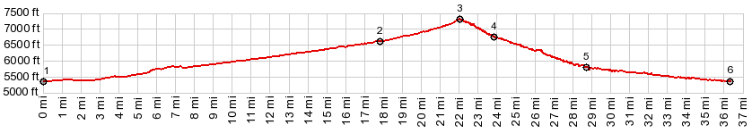
Gate Canyon crosses from the
Unita Basin over part of the West Tavaputs
Plateau into Nine
Mile Canyon. It is one of two summits
on the extremely bike friendly and scenic
route between Myton and Wellington. The
north approach to this summit is now the
only part of the Myton-Wellington Route,
that is not paved. But going up it
should not be a problem for any road bike.
Starting from about the
turnoff to Five Mile Draw Rd, a juniper
dwarf forest lines the road, finding shelter
from the wind between the badland ridges. At
the top dirt roads cross in both directions
and the pavement stops
From
North. (also described upwards). The
profile starts in the lowest part of Nine
Mile Canyon. This lower part of the canyon
has the highest walls and is the most
impressive. The first couple of miles after
the turnoff up Gate Canyon are paved. The a
good, partially hard medalled dirt road,
climbing in tight curves between a wide dry
creek and red rock fingers and walls. Slideshow
of northern approach and summit
This just may be the most
interesting of the three approaches. At
point 4 Wrinkle Rd climbs back up a short
distance towards a lower edge of the
plateau. If I remember right , the sign at
point 4 reads "Sand Creek Rd", which is true
in a way, because Wrinkle Rd ends on Sand
Creek Rd, which is the main road to a common
destination. Wrinkle Rd runs along close to
the canyon rim. At first it is very gentle,
but distinct decent towards the Green River.
Later various short out and backs lead to
isolated canyon rim points. Before reaching
the junction with Salt Wash Rd, the road
touches the rim at various points. The last
several miles are common to the Sand Wash Rd
summit. Here the road surface becomes
a little harder to ride (sand). But scenery
compensates in the form of various cream
colored formations, forming cliffs and
buttes next to the road. After all those miles of
possibly seeing no vehicles, it comes as a
surprise, that there is a fully functional
ranger station down here at the boat launch,
and rows of parked cars.
Slideshow
of alternate approach from west
Dayride with this point
as highest summit:
PARTIALLY PAVED / UNPAVED ( < Cold Springs SWA(sh) | same page > ) Gate Canyon s(u) , Sand Wash Rd s(u) : a short distance up Five Mile Draw Rd > down Five Mile Draw Rd > Nine Mile Canyon Rd south > Gate Canyon s(u) > Wrinkle Rd east <> out and back to canyon rim to the south >> Sand Wash area with a detour along river to the north > Sand Wash Rd west and south > Sand Wash Rd s(u) > Sand Wash Rd south > Pariette Rd west > 10000 South St, Myton west > Nine Mile Canyon Rd north > back up Five Mile Draw Rd back to starting point: 91.6miles with 6200ft of climbing in 8:29hrs (garmin etrex30 m3:20.5.20) Notes: the plan was to cut over from Sand Draw Rd to Nine Mile Canyon Rd. But none of the intersections are marked and many dead end at well sites. ( < same page | Mt Harrison(ow) > ) Gate Canyon s(u) x2 : : a short distance up Five Mile Draw Rd <> down Five Mile Draw Rd <> Nine Mile Canyon Rd south <> Gate Canyon s(u) <> Nine Mile Canyon Rd east <> up Argyle Canyon Rd << turnaround point at ~6700ft after ~15 miles on Argyle Canyon Rd: 52.9miles with 3800ft of climbing in 5:05hrs (garmin etrex30 m3:20.5.22, t20_02). |
|
|
advertisement |
|
|
advertisement |