| |
| |
Mt Harrison(ow) The best motivation for this
climb is a view from below. Two rounded
peaks with snow lasting into June, share
the backdrop to the collection of houses,
named Elba. While access to one of the
peaks in the view, Cache Peak, from this
side is not as easy as it first looks on
the map, a excellent paved road leads to
the top of the northern peak, Mt Harrison,
also the site of the Pomerelle Ski Area.
Approaches
My favorite spot on this ride
is actually not the summit, but the area
where the first view of Cache Peak to the
north appears. A sign explains the
historical trapping accomplishments of Peter
Skene Ogden, who named this peak, and whose
name figures prominently in Utah landmarks
to the north. A number of large stray rock
outcrops seem to be strategically placed by
nature to highlight this spot, and the sign
adds a cognizant touch of history. There are
also two campgrounds near this location. The road climbs past a small lake below. The Snake River Plain and the maze of grass canyons to the west are lost in the thick haze of June. The road gently curves to the very highest point of this giant aunt hill. The summit is shared with a two-story lookout structure, a toilet building, and a small rock plaque honoring WW2 casualties.
Dayride with this point
as highest one way summit (and no
two-way summits):
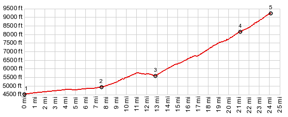
COMPLETELY PAVED: ( < Gate Canyon s(u) | Beaverland Pass > ) Mt Harrison(ow): jct Howell Canyon Rd - Connor Ridge Rd <> down Howell Canyon rd <> Nv77 south <> Elba - Alma Hwy << turnaround point a couple of miles south of Elba <> separate out and back on the way out from Elba <> Elba Grandview Cemetary <> separate out and back from starting point <> up Howell Canyon Rd << turnaround point at end of road: 46.0miles with 5100ft of climbing in 4:59hrs (garmin etrex30 r4:20.6.4, t20_04) Notes: road above ski area was still closed but only contained one drift that required a detour around the road. |
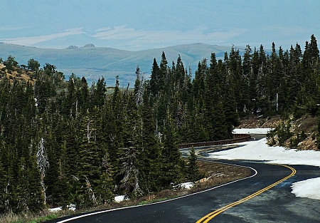 About a mile or
so north of the Connor Creek Summit, the
road to the ski area takes off. The road
climbs steeply in the sage hills up to a
forest, on the flank of a small ravine. The
best part of this ride is above the ski
area. After this short episode of forest,
the surroundings change again to a sloping
sage plain.
About a mile or
so north of the Connor Creek Summit, the
road to the ski area takes off. The road
climbs steeply in the sage hills up to a
forest, on the flank of a small ravine. The
best part of this ride is above the ski
area. After this short episode of forest,
the surroundings change again to a sloping
sage plain. |
|
advertisement |
|
|
advertisement |