| |
| |
FR113 Winkler Point s(u)
I really hadn't planned on riding
this summit, at least not at the time I did. My
aim was to get over the more interesting appearing
FR123 summit in the Tushar Mountains. But there
are two things, that limit a bike ride in Utah in
June. Either it's too hot at low elevations, or
there is still too much snow at the really high
elevations. In this case the latter was the case.
FR123 was still snow covered over the top - not a
flake of snow on FR113, but it was still very hot.
Nice ride - but I think FR123 would be much more
scenic.
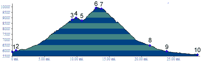
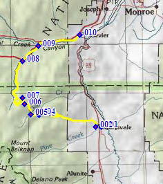
From South. The profile starts on
US89 in Marysvale and turns up Center Street.
Center Street really looks no different than any
of the parallel streets, except that maybe it has
an old building along the way that used to be some
sort of business in a past era. On the west end of
town three forest access routes meet. This one is
labeled as going to upper Kimberly, the name of an
old mine. A good dirt road climbs a hill outside of town
and then dips down to meet Deer Creek. The road
ahead, seen in form of a road cut far above, soon
becomes visible. In order to gain all that
altitude the road uses several long ramps and is
intermittently very steep. The most amazing sight
along the way, in my opinion, is the road cut for
FR123, still much further up, on the treeless
colorful rock slopes, around the Mount Belknap
area. Soon after the jct with FR123 the road reaches an
intermediate summit in the forest and descends
towards a low point at the jct with Deer Creek
Trail, an ATV option that comes up from north of
Marysvale. The remaining climb to the summit is
steeper and rougher than before, and passes a few
old mining remnants. There are only very limited
views from the top. One picture was taken a few
hundred yards up FR1047 to get a better view 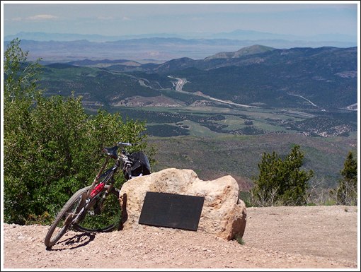 Winkler Point From North. (described downwards). The
road curves around to the west, and a far view
into the lower Pavant Range, separated from the
mountains we are on, by I70 cutting through the
landscape like some sort of unnatural cosmic
boundary. A simple stone plack mentions Mr Winkler
and his forest service career. A wide road with farily deep gravel leads down to
follow Mill Creek. Turning around, none of the
higher peaks are visible from the road. The dirt
road passes under I70 and the follows Clear Creek
north of the interstate to the first on ramp. This
is also the exit for the Fremont Indian State
Park. The profile continues on I70 to a low point,
where the road crosses Clear Creek just before the
US89 Marysvale exit. 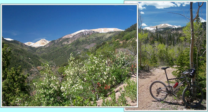 left: above Deer Creek, heading for Winkler Point or the summit on FR123 in the Tushar Mountains left: the same range from a few hundred yards up FR1047 To complete the loop back to Marysvale, an
wonderful bike path follows an old railbed through
Marysvale Canyon, but only as far as the Big Rock
Candy Mountain RV resort. From there it's just a
few more miles on the road, supplied with fresh
water from the resort. Dayride PARTIALLY PAVED / UNPAVED ( < FR111
Joseph Peak s(u) | FR106
Devil's Dance Floor > )
back to cycling Utah's summits and passes |
||||||||||||||||||||||||||||||||||||||||||||||||
 Approaches
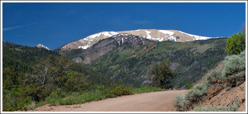
|
|
advertisement |
|
|
advertisement |