| |
| |
FR106 Devil's Dance
Floor s(u)
The first time I camped on FR106
to do this ride, I had to postphone my plans due
to snow. The second time I camped at the identical
spot several years later, the following day
brought record heat for June, and the ride turned
out much different than I had first imagined
it. Actually the best part of the loop was finally
finding the first tree, big enough to give shade
to my entire body after the monotonous hot stretch
on I15. These trees were located in a traffic
island between the I15 - I70 interchange. But they
were just fine for an extended rest, and drinking
whatever water I had left. But I hope the picture
shows, that there are also a few very nice views
of the Tushar Mountains along the way, especially
during periods of cool weather.
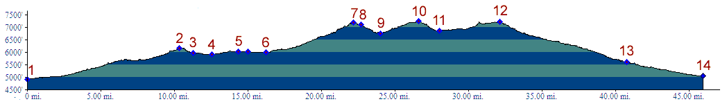
From South. The ride along this profile
starts out in a strangely unappealing way, so
strange in some way, that somebody might consider
it strangely appealing, because it is a sign of
the culture we live in. The ride starts on the
shoulder of I15 through bone dry dessert, being
passed by lots of big boats, towed by cars of
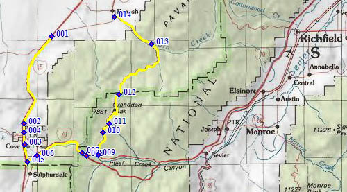
course. The boats are on their way to Lake Powell. The profile turns off I15, just to enter another
interstate, I70, after having crossed a high point
on I15: Cove Fort - Dog Valley Pass. This is the
way I happened to ride the route, but the logical
thing to do would have been to get off I15 and
point 4 and back onto I70 at point 6. One single gradual turn with one single gradually
changing view to the east leads to the top of a
signed summit, where this Interstate reaches its
highest point in the Pavant Range. Soon after
that, the route gets off the Interstate and all
that noise is finally over. There have been a few fleeting views of the peaks
in the Tushar Mountains already, but the first
really nice ones come, within a few miles after
the dirt road turnoff to FR106. (Turnoff is
labeled as going to Three Creeks Reservoir). But
you have to turn around, so that it's easy to
miss. The road reaches a high cow grazing meadow,
which carries the mysterious name "Devil's Dance
Floor". But the views enjoyed from this dance
floor by the cows must be some of the best views
enjoyed by bovines on the planet. Three Creeks
Reservoir is just west of here. 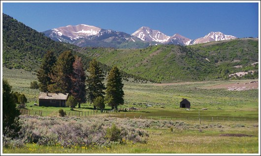 From North. (described downwards) Rolling
onwards through these juniper hills, the road
passes another point almost as high as the summit,
as the road skirts east of Mary's Nipple (no
relation to Mary's Nipple in the Wasatch Plateau
near Salida - or maybe they are related, but they
definitely are different mountains). The further descent has no more exciting views,
just pleasant Juniper Hills and a slope which
hardly requires breaking. Approaching the Adelaide
campground, the surface is more deeply graveled,
and less pleasant to ride. Shortly below that, it
becomes hard medaled. The profile ends in the town
of Kanosh, which has a gas station, so at least
one can get water there. Dayride: PARTIALLY PAVED / UNPAVED ( <FR113
Winkler Point | Success Summit>
)
back to cycling Utah's summits and passes |
||||||||||||||||||||||||||||||||||||||||||||
 Approaches
|
|
advertisement |
|
|
advertisement |