| |
| |
Cedar Breaks summit(u)
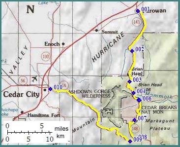
The route to Cedar Breaks
National Monument is steep, long and high, or
just plain old big, located in the Markagunt
Plateau east of Cedar City. This is especially
true for the northern approach via Main Canyon
(that's a name). At the top, inside the National
Monument, a number of high overlooks onto pink
cliffs, wait for the exhausted cyclist, no
matter when he gets here. The approaches from
the east (not shown below) are not as high or
steep as the ones shown below.
This great climb is
not an officially named summit. But it is close to
the officially named and signed Mammoth Summit.
But it is not a necessary condition to cross
Mammoth Summit go get to Cedar Breaks, and
therefore I think of Cedar Breaks as a separate
summit. Oddly enough Mammoth Summit is not the
highest point on the route over it, no matter how
you approach it.
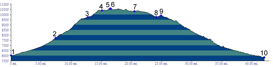
From North. Seven miles after leaving
Parowan, you look around from the saddle and
conclude that the scenery hasn't changed much,
even though it certainly feels like you have been
riding uphill. Turning around to look back brings
verification that you have been climbing. You are
now close to even with the top of the reddish
foothills east of Parowan. Some cars coming down are accompanied by a strong
brake pad smell. I guess this is one way to gauge
the overall size and steepness of an approach.
Using this nose method there still is a lot of
climbing ahead. After another long, steep section a new piece of
scenery comes into sight, the developments of the
Brian Head ski area. "Reserve your condo now -
starting at $400 000" demands a billboard. - Most
certainly, what else could I do with 400 000
dollars ? The billboard does not recognize I am
not a target audience for such an offer, and don't
intent to become one". Just let let me ride to
this top of this big hill! Contained in the cookie
cutter architecture are also a bicycle store next
to an ATV rental business. They advertise their
business side by side in apparent peaceful
coexistence. By
From South. (described downwards) A short
traverse through aspen forest is followed by a few
sweeping curves and deliver the rider to the
junction with Cedar
Canyon summit, just east of its top. The
profile shows the descent on that route into Cedar
City. Dayrides with this point as highest summit COMPLETELY PAVED Cedar Breaks s(u) , Cedar Canyon
Summit , additional out ad back: Ut14,
Navajo Lakes area > Ut14 west > Cedar Canyon
Summt > Cedar City > roads parallel to I15
north east > Parowan > Ut148 south >
Cedar Breaks s(u) > Ut14 east back to starting
point in Navajo Lakes area: 86 miles with 6800ft
of climbing in 7 hours (m3:06.09.29). ( < Hancock
Rd s(u) | Kolob Terrace
s(u) > ) Cedar Breaks s(u) , jct Ut143 - Mammoth Creek
Rd(sh) , jct Ut14 - Mammoth Creek Rd(sh) ,
additional out and back: apr jct FR63 Stout
Canyon - Ut14 > Ut14 west > turnoff to Cedar
Breaks NM <> out and back to summit of Cedar
Canyon Summit >> Ut148 north > Cedar
Breaks s(u) > Ut143 east > jct Ut143 -
Mammoth Creek Rd(sh) <> out and back on
Ut143 to Panguitch Lake > Mammoth Creek Rd
south > jct Ut14 - Mammoth Creek Rd(sh) >
Ut14 east back to starting point: 69.7miles with
6140ft of climbing in 6:41hrs (garmin etrex30
r4:19.10.10)
back to
cycling Utah's summits and passes
|
 Approaches
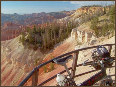 now the
smell of descending brake pads has mostly
disappeared. But it is still noticeable. There is
breathtaking scenery along this route, and not
just smelly brakepads anymore, but beautifully
breathtaking. But you have to work for it. The
attractions are all located on the very top. A
large, sweeping S curve, now climbing steeply
again, brings the cyclist near the top of the ski
lifts, and Brian Head Mountain. The road travels
out onto the plateau and passes a summit sign
stating 10400ft, just before the split of Ut148 to
Cedar Breaks and Ut143 to Panguitch (Mammoth
Summit). Continuing on Ut148, the road climbs
further, and suddenly, without warning delivers
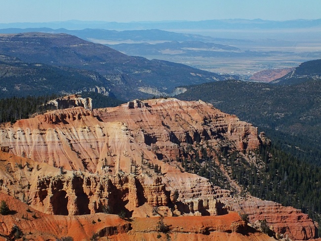
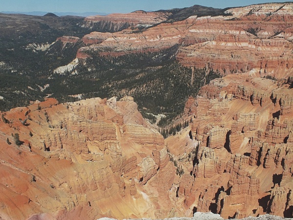
the exhausted cyclist to an edge-of-the-world type
overview, onto the pink cliffs of Cedar
Breaks.National Monument. Several overlooks follow
in quick succession at the same or slightly higher
altitudes. Finding the exact highest point is
difficult on this rolling plateau summit.
now the
smell of descending brake pads has mostly
disappeared. But it is still noticeable. There is
breathtaking scenery along this route, and not
just smelly brakepads anymore, but beautifully
breathtaking. But you have to work for it. The
attractions are all located on the very top. A
large, sweeping S curve, now climbing steeply
again, brings the cyclist near the top of the ski
lifts, and Brian Head Mountain. The road travels
out onto the plateau and passes a summit sign
stating 10400ft, just before the split of Ut148 to
Cedar Breaks and Ut143 to Panguitch (Mammoth
Summit). Continuing on Ut148, the road climbs
further, and suddenly, without warning delivers
the exhausted cyclist to an edge-of-the-world type
overview, onto the pink cliffs of Cedar
Breaks.National Monument. Several overlooks follow
in quick succession at the same or slightly higher
altitudes. Finding the exact highest point is
difficult on this rolling plateau summit.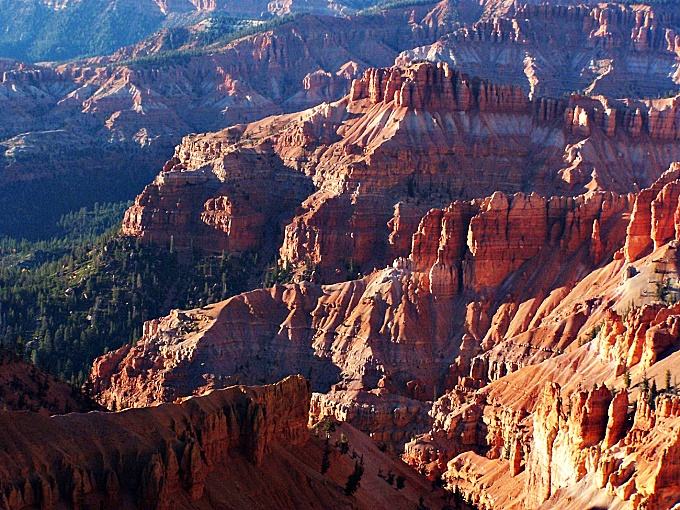
|
|
advertisement |
|
|
advertisement |